Designs · 2016 — 2024

Site plans for gardens, farms and water systems.

Site plans for community gardens, crèches, schools and farms in South Africa and Lesotho. Follow the design from base map to water management and planting, then open any sheet to see the detail.
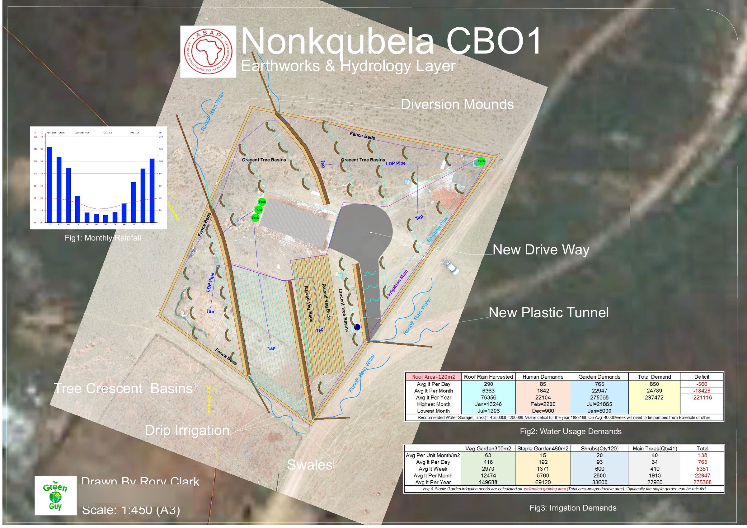
Nonkqubela site drawing, with swales, basins, tanks and pipe runs laid over an aerial survey
From survey to planted groundExplore the three layers
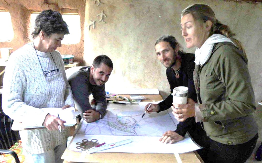
Rory Clark and fellow Permaculture Design Course participants working around a hand-drawn site plan
Design practice during my Permaculture Design Course

Learning to see the whole site

A design begins with observation and conversation.

Working around a shared plan during my PDC. The same habit runs through the drawings below: understand the site, work through the relationships between water, access and planting, then make the plan useful to the people who will build it.

Explore teaching and practical learning

One site, three layers

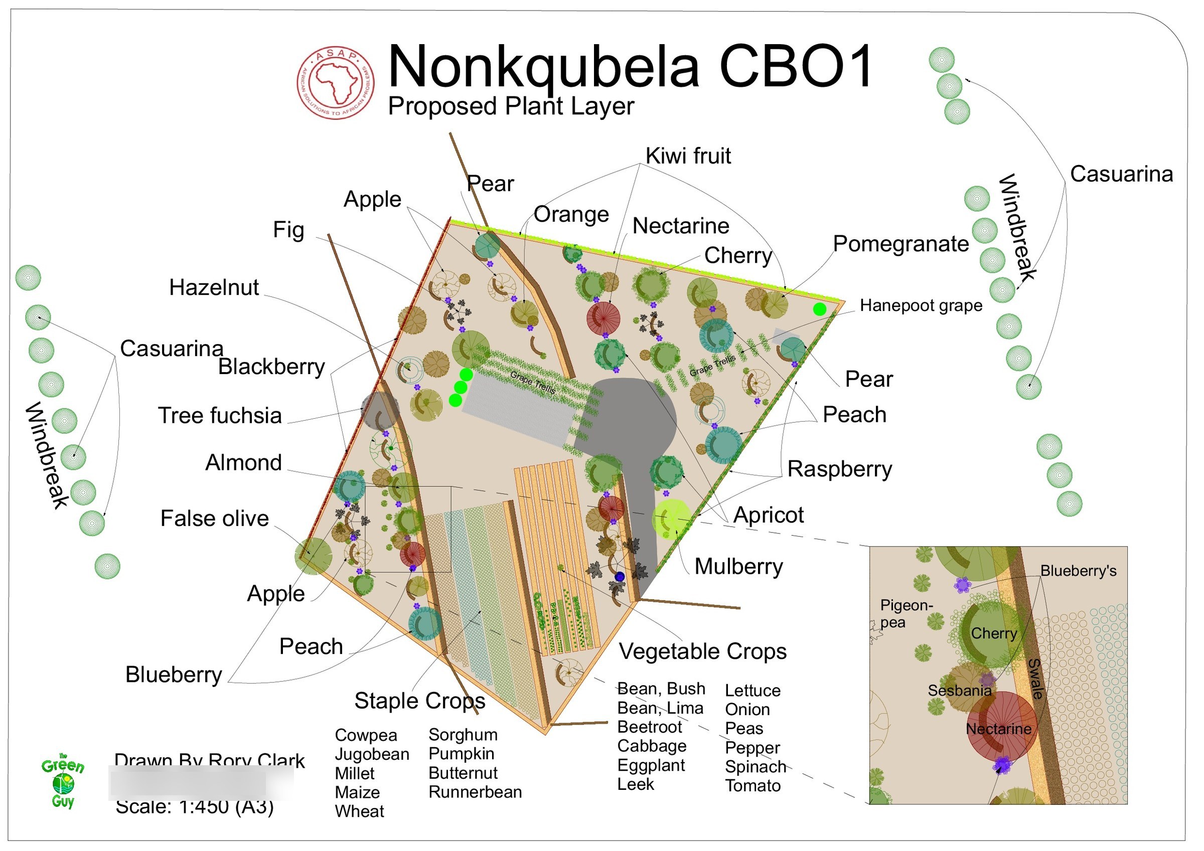
Nonkqubela CBO1: site survey, water and planting.

Three design layers for a community garden near Matatiele, Eastern Cape. The base map records boundaries, buildings, slope and climate. The earthworks plan locates swales, basins, tanks and pipes; the planting plan identifies trees and crops.
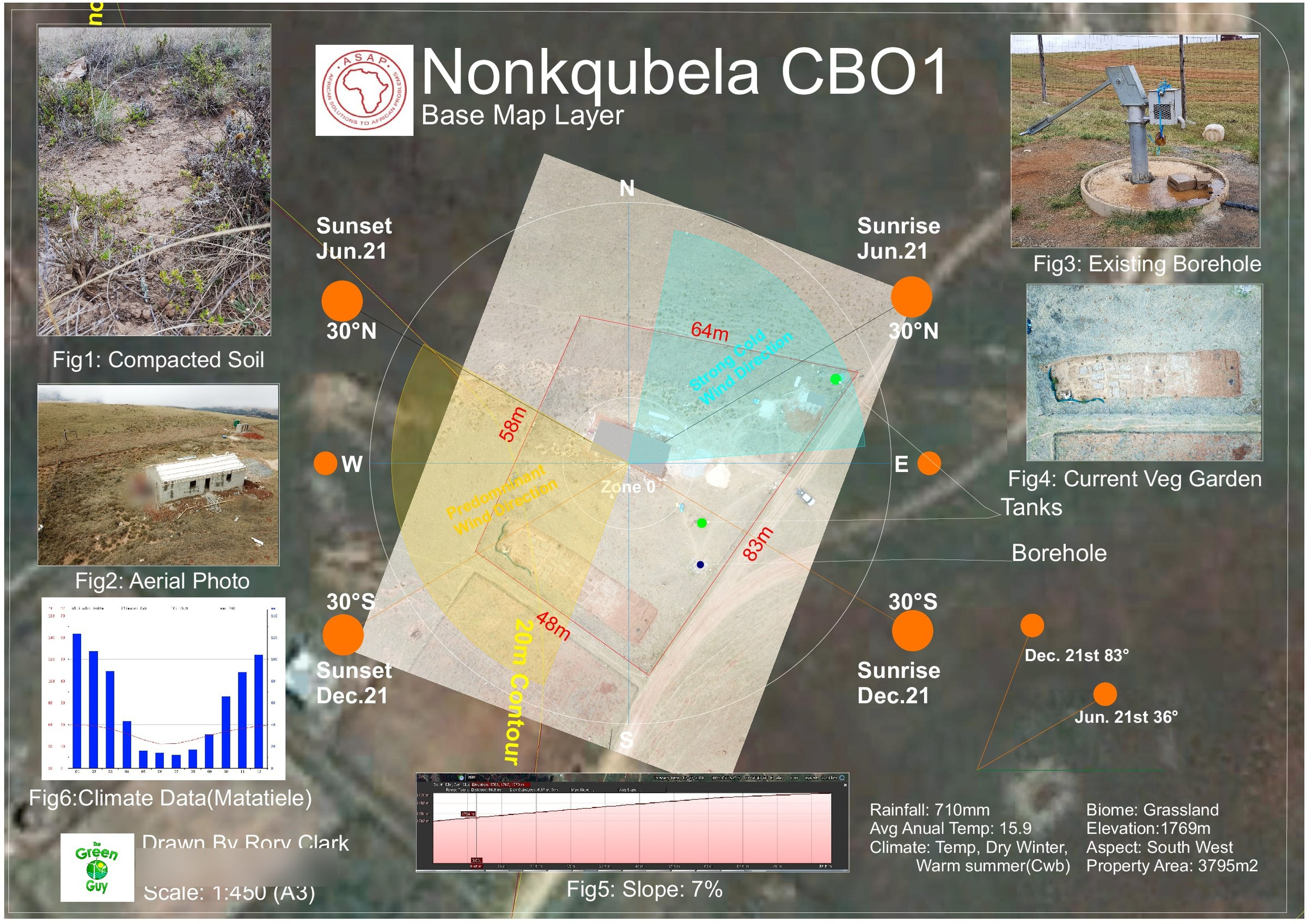
A3 base-map sheet for Nonkqubela CBO1: a drone orthophoto of the site with the boundary, buildings, slope arrows, sun-angle diagrams and a climate panel drawn around it
01Base mapNonkqubela CBO1 · December 2019 · drone orthophoto on Google Earth imagery
A3 earthworks and hydrology sheet for Nonkqubela CBO1: swale lines, basins, a tank and pipe runs drawn over the drone orthophoto, with a legend
02Earthworks & hydrologyNonkqubela CBO1 · December 2019 · drone orthophoto on Google Earth imagery
A3 proposed plant layer for Nonkqubela CBO1 on a white ground: tree canopies drawn as circles, vegetable beds as hatched blocks, each species named with a leader line
03Proposed plant layerNonkqubela CBO1 · December 2019

ASAP community-based organisations · Matatiele, Eastern Cape

Silukhanyo, Sinikithemba and Reahasetjhaba.

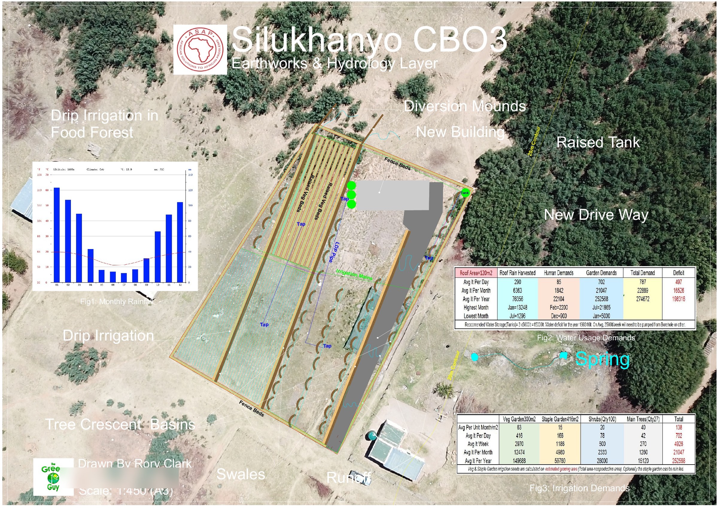
Site surveys, water systems and planting plans for three community-based organisations in the ASAP programme near Matatiele. The drawing files are dated December 2019; the programme engagement is recorded separately as 2023.
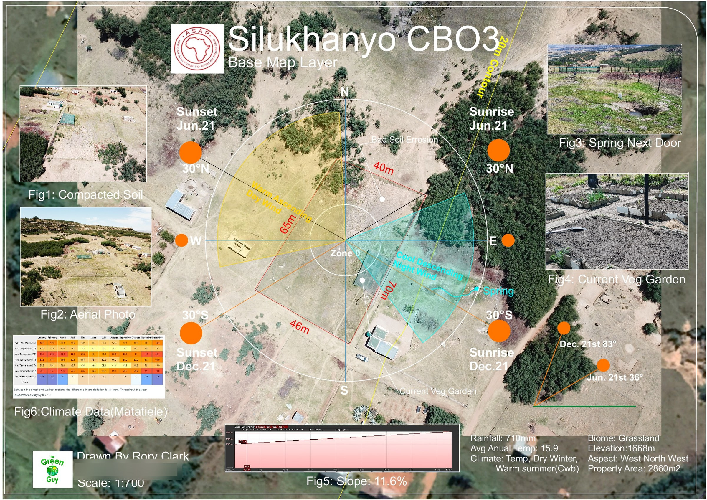
A3 base-map sheet for Silukhanyo CBO3: drone orthophoto with the site boundary, buildings, slope and sun-angle diagrams
Silukhanyo CBO3 · Base mapDecember 2019 · drone orthophoto on Google Earth imagery
A3 earthworks and hydrology sheet for Silukhanyo CBO3: swales, basins and pipe runs over the drone orthophoto
Silukhanyo CBO3 · Earthworks & hydrologyDecember 2019 · drone orthophoto on Google Earth imagery
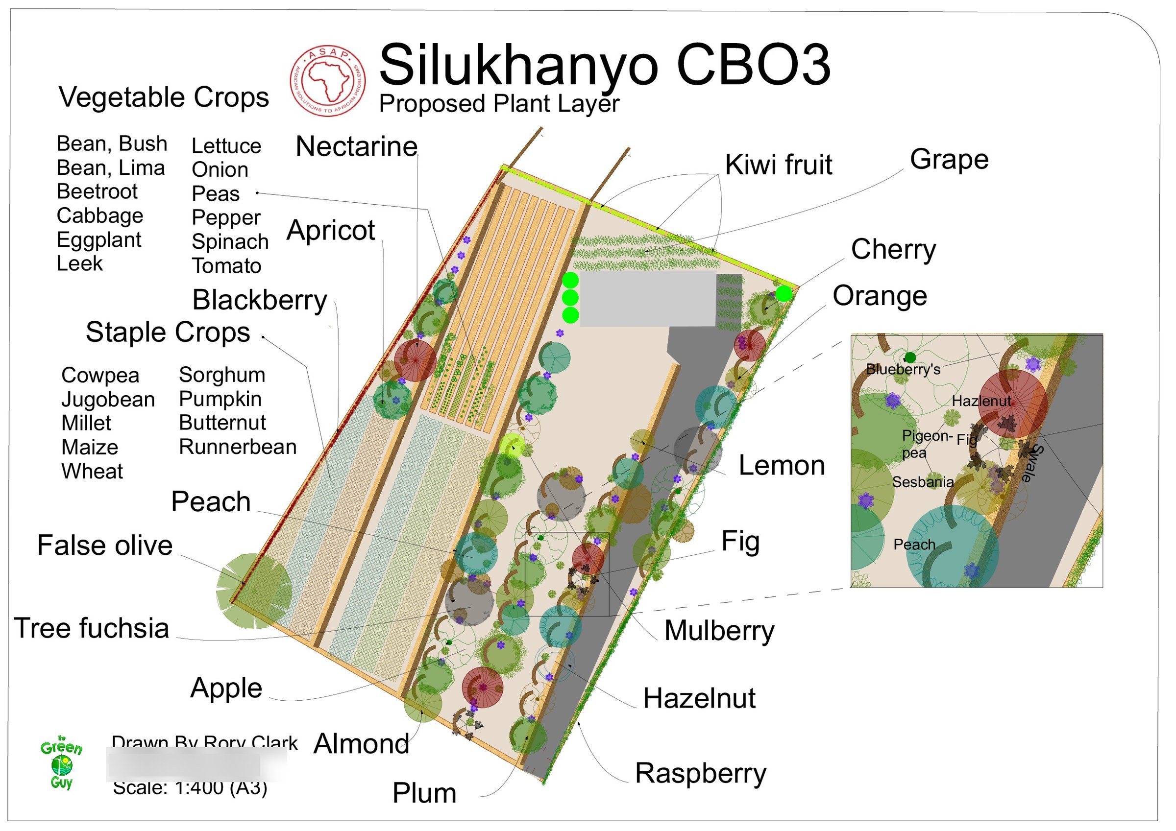
A3 proposed plant layer for Silukhanyo CBO3 on a white ground: tree circles, hatched vegetable beds and named species
Silukhanyo CBO3 · Proposed plant layerDecember 2019
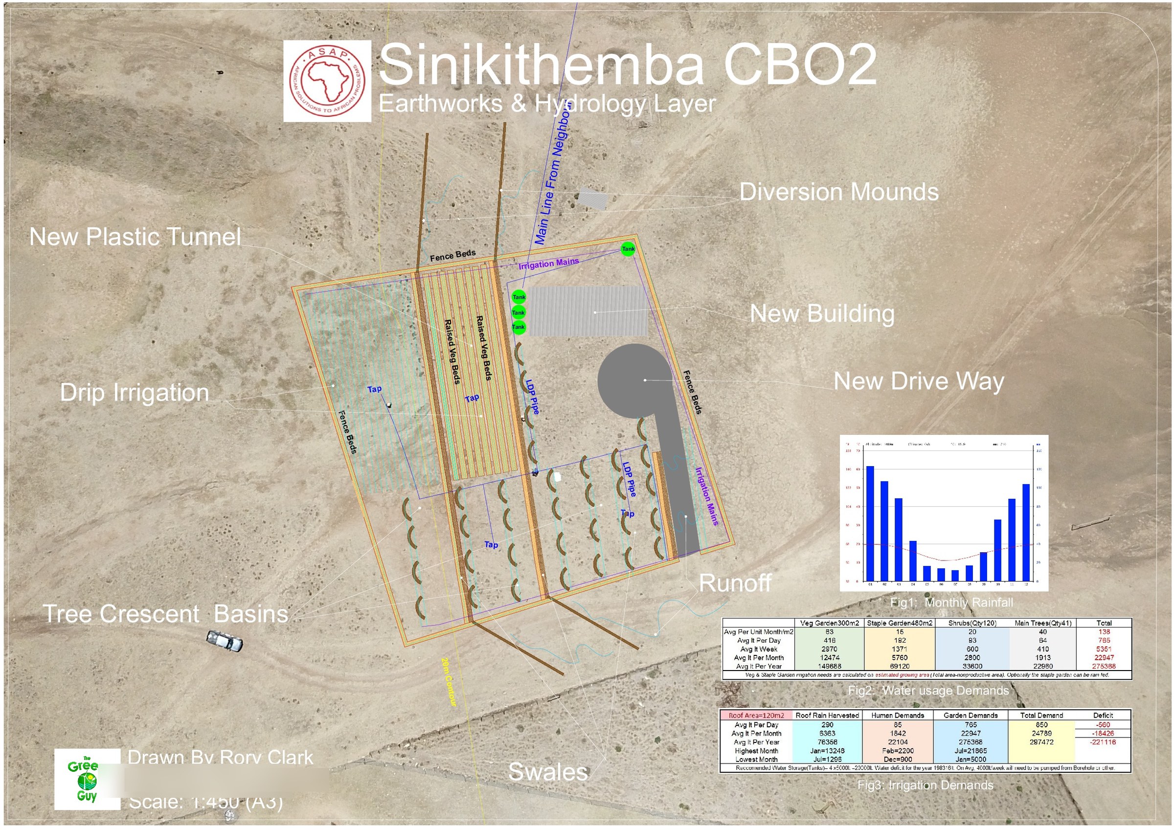
A3 earthworks and hydrology sheet for Sinikithemba CBO2: swales, basins and pipe runs over the drone orthophoto
Sinikithemba CBO2 · Earthworks & hydrologyDecember 2019 · drone orthophoto on Google Earth imagery
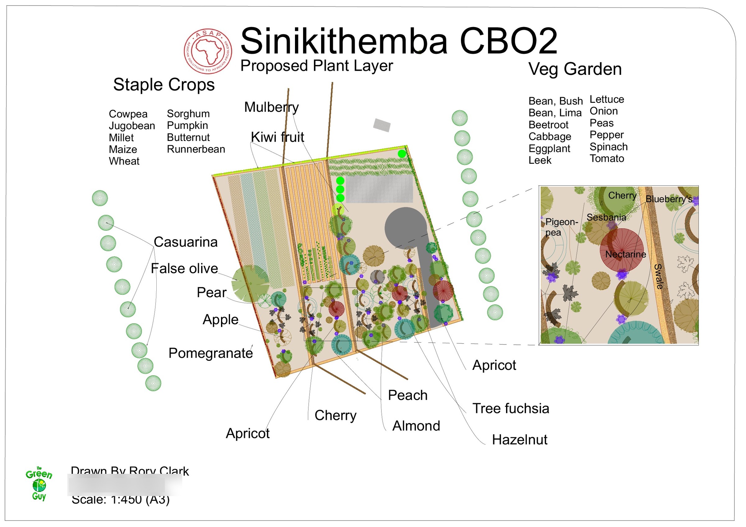
A3 proposed plant layer for Sinikithemba CBO2 on a white ground: tree circles, hatched beds and named species
Sinikithemba CBO2 · Proposed plant layerDecember 2019
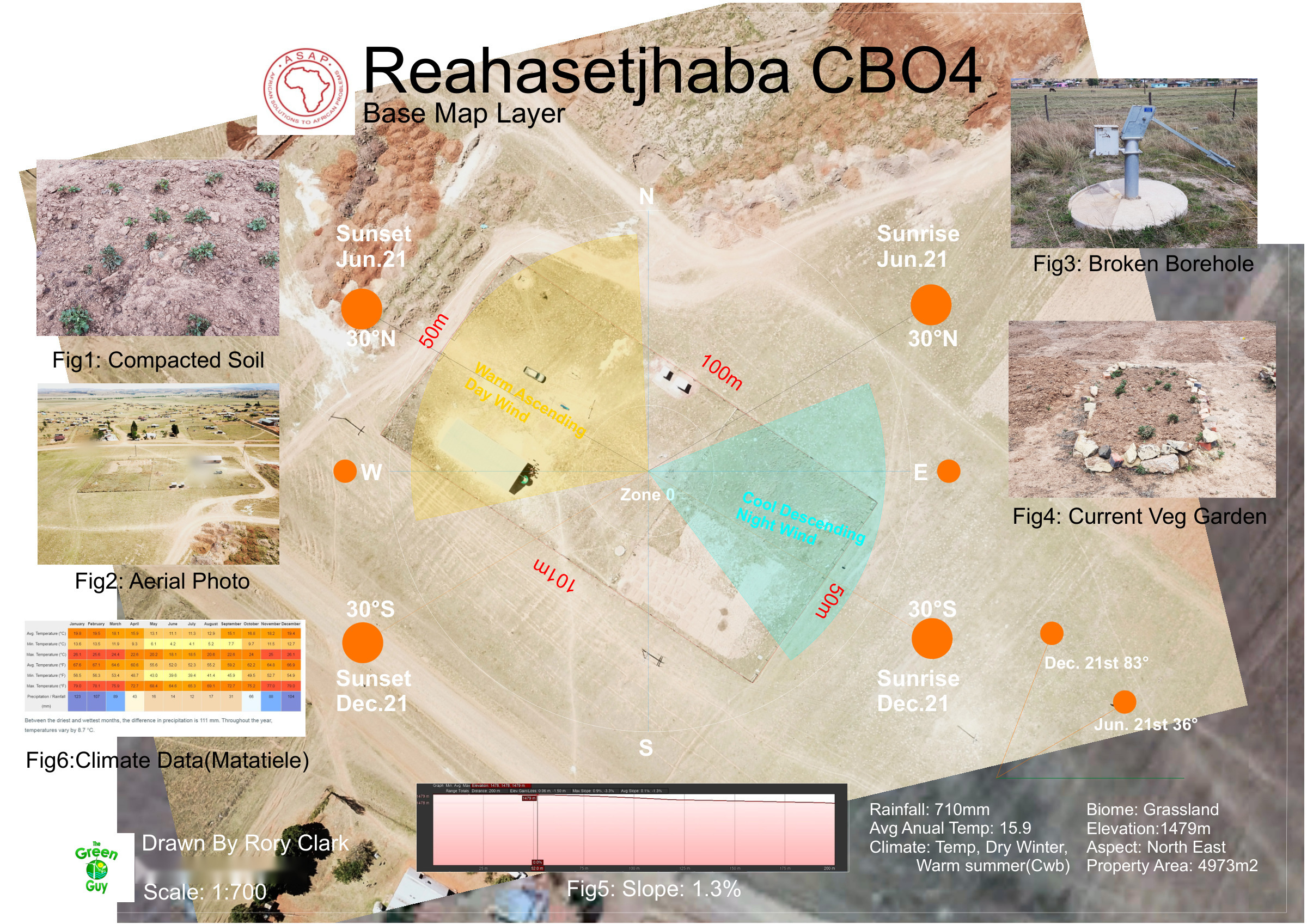
A3 base-map sheet for Reahasetjhaba CBO4: drone orthophoto of the fenced site on Google Earth imagery, with inset photographs of the compacted soil, the site from the air, the broken borehole and the existing vegetable garden, a slope diagram and a climate panel
Reahasetjhaba CBO4 · Base mapDecember 2019 · drone orthophoto on Google Earth imagery
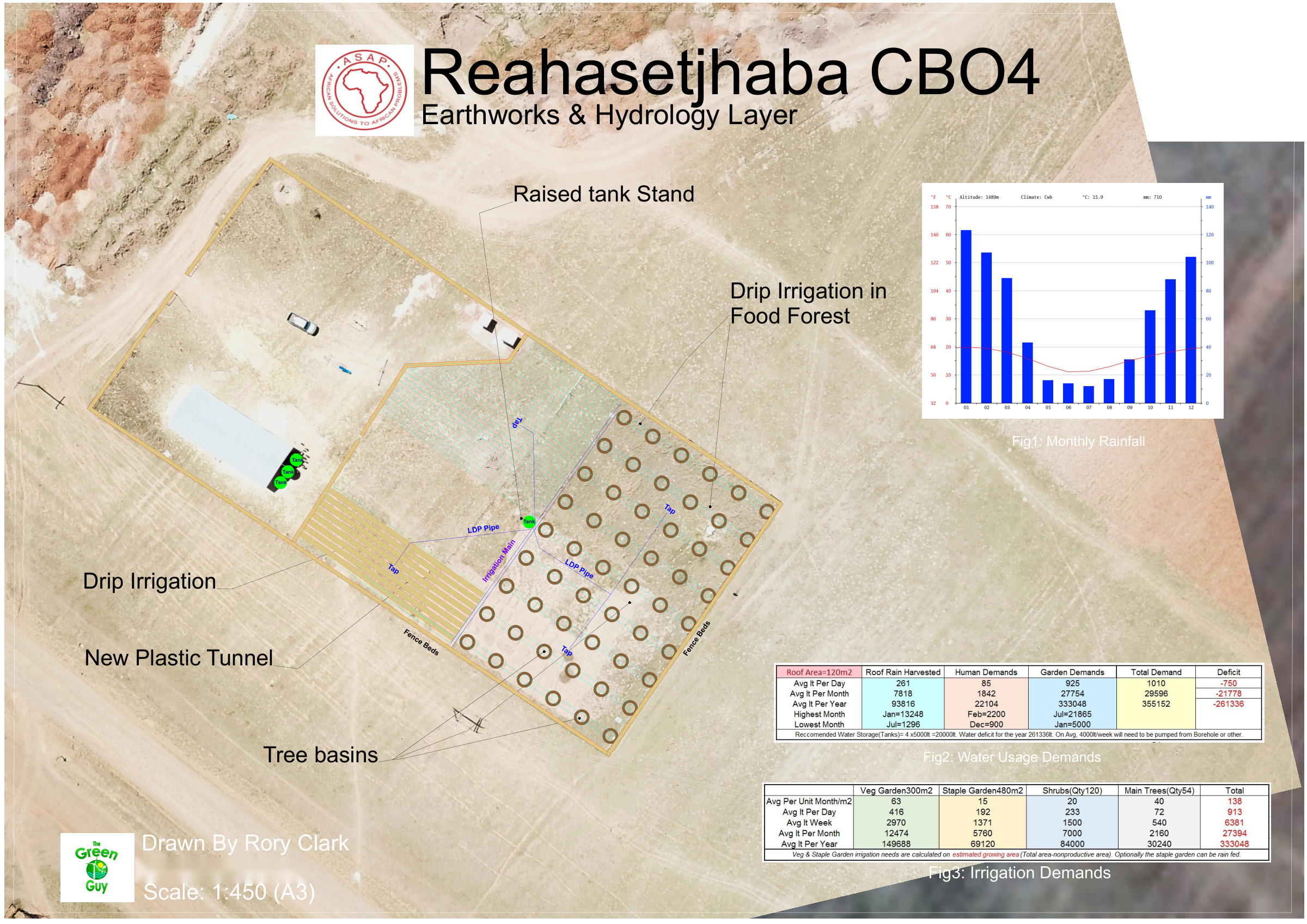
A3 earthworks and hydrology sheet for Reahasetjhaba CBO4: swales, basins and pipe runs over the drone orthophoto
Reahasetjhaba CBO4 · Earthworks & hydrologyDecember 2019 · drone orthophoto on Google Earth imagery
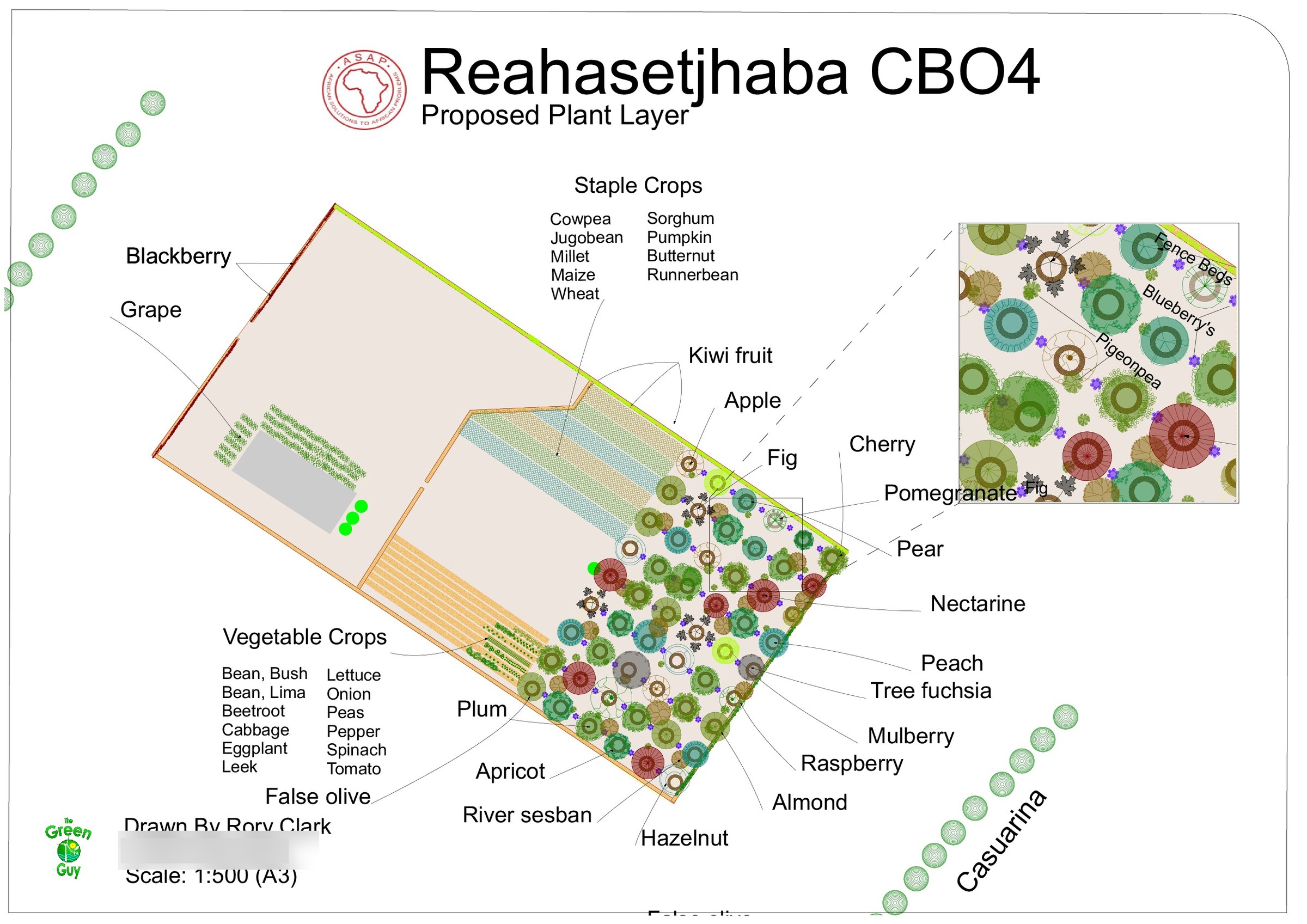
A3 proposed plant layer for Reahasetjhaba CBO4 on a white ground: tree circles, hatched beds and named species with leader lines
Reahasetjhaba CBO4 · Proposed plant layerDecember 2019

Ithala Permaculture Design Project · KwaZulu-Natal

Water and garden plans for four crèches.

Earthworks, irrigation and land-use plans for African Conservation Trust’s Ithala project, drawn between 30 November and 3 December 2020. The selected sheets cover Syathokoza, Zamokuhle, Ithembalethu and Masithuthuke crèches.
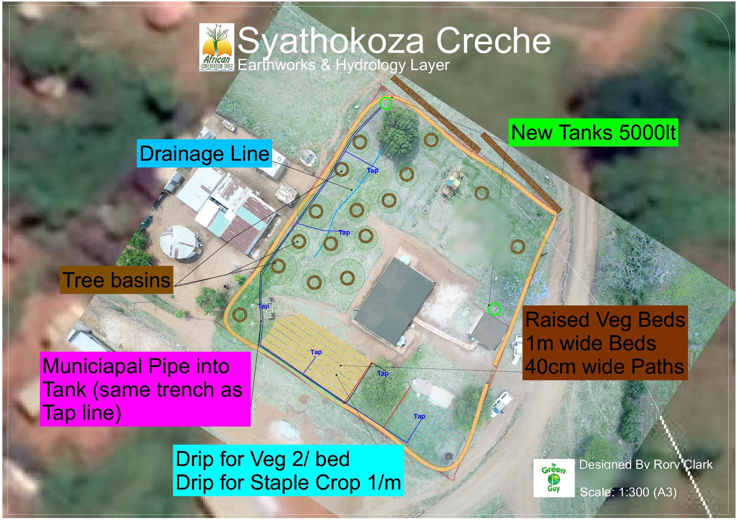
A3 earthworks and hydrology sheet for Syathokoza Crèche: a drainage line, new tanks, a municipal pipe run and drip lines drawn over satellite imagery of the crèche
Syathokoza Crèche · Earthworks & hydrology30 November 2020 · base imagery: Google Earth
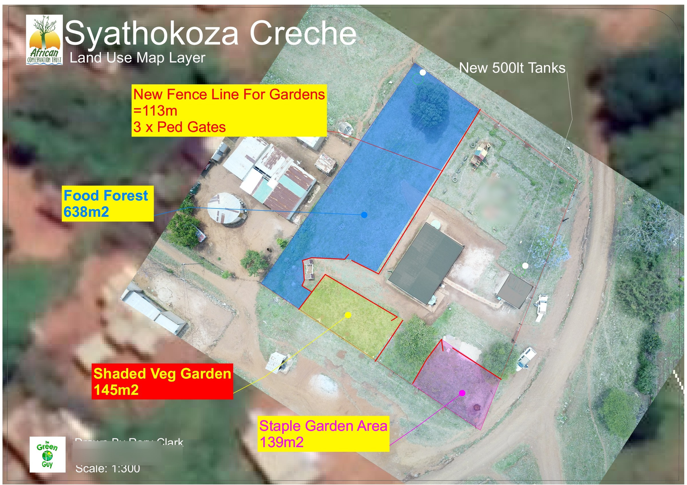
A3 land-use sheet for Syathokoza Crèche: three colour-coded garden zones drawn over satellite imagery of the crèche
Syathokoza Crèche · Land use30 November 2020 · base imagery: Google Earth
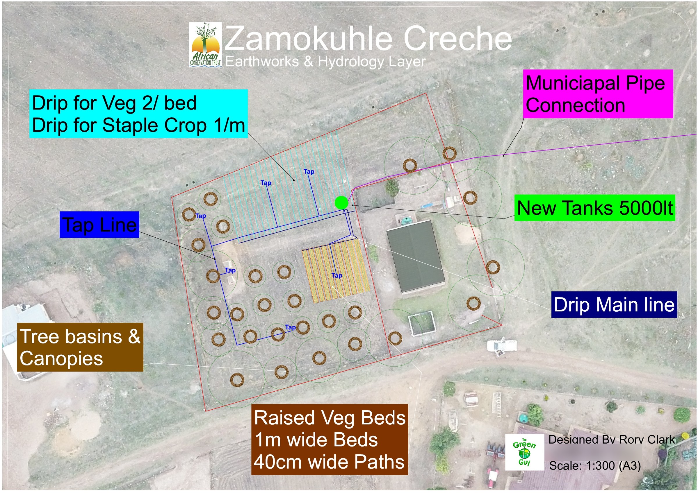
A3 earthworks and hydrology sheet for Zamokuhle Crèche: earthworks lines, tap lines and labelled callouts drawn over satellite imagery
Zamokuhle Crèche · Earthworks & hydrology1 December 2020 · base imagery: Google Earth
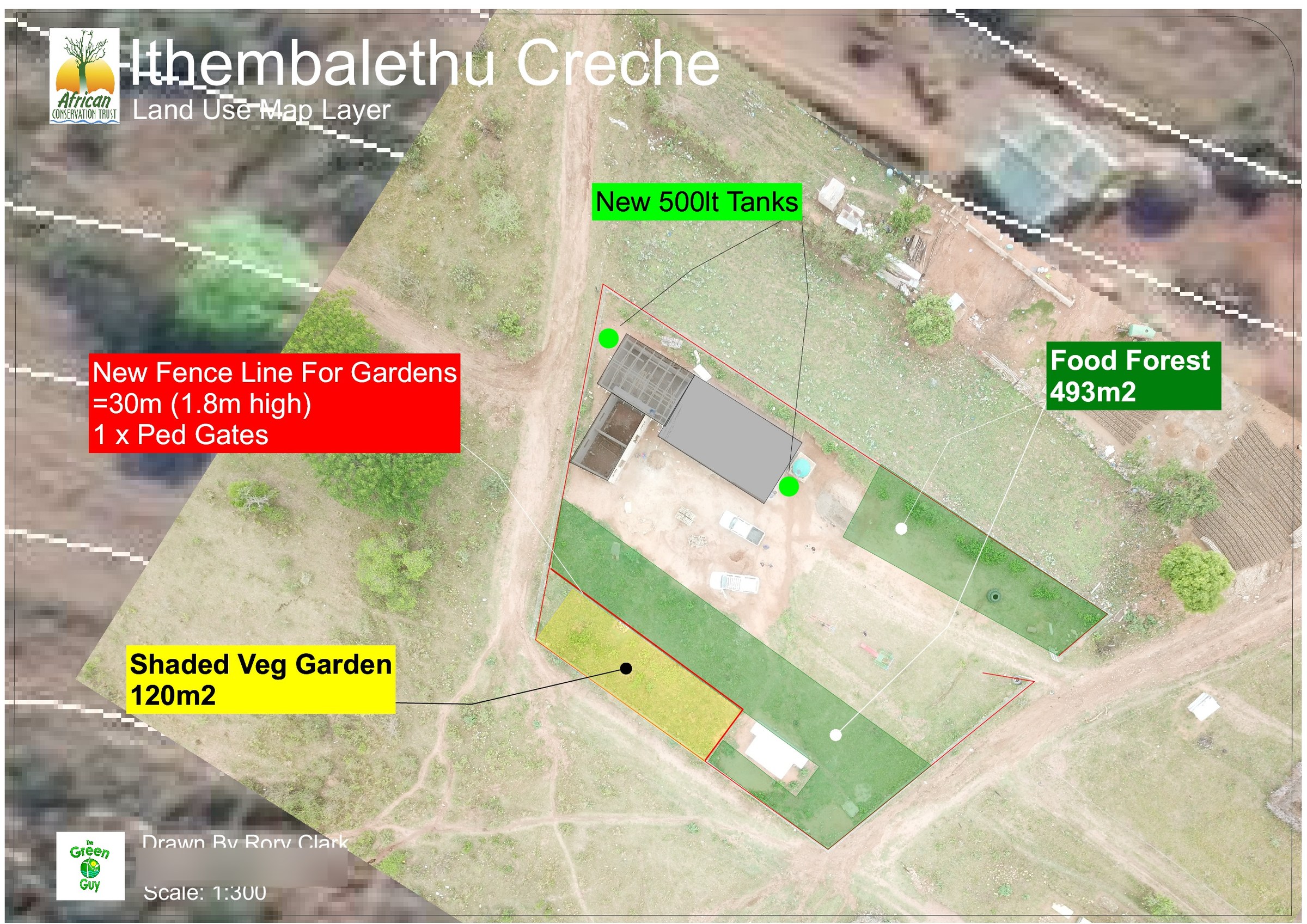
A3 land-use sheet for Ithembalethu Crèche: coloured zones for gardens, orchard and access drawn over satellite imagery
Ithembalethu Crèche · Land use1 December 2020 · base imagery: Google Earth
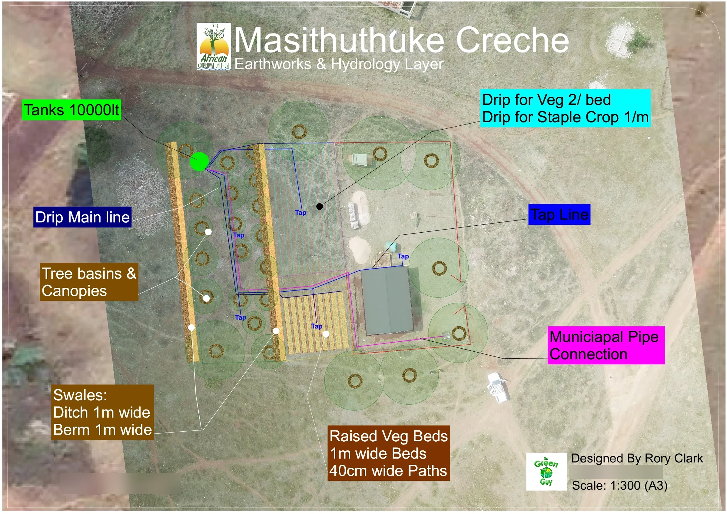
A3 earthworks and hydrology sheet for Masithuthuke Crèche: swales, tanks and pipe runs drawn over satellite imagery
Masithuthuke Crèche · Earthworks & hydrology3 December 2020 · base imagery: Google Earth
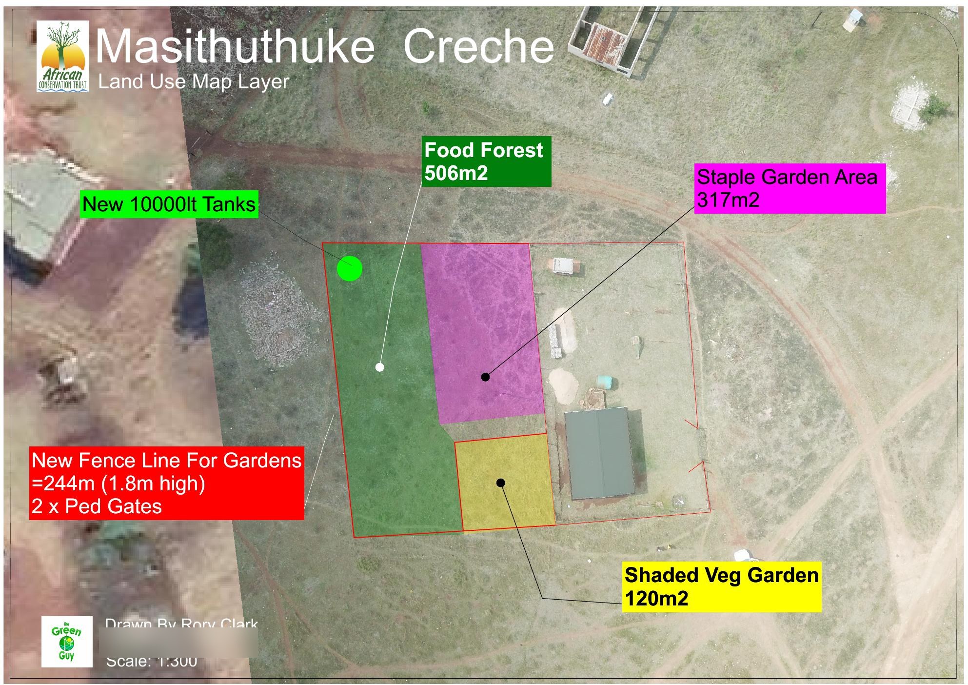
A3 land-use sheet for Masithuthuke Crèche: colour-coded garden zones drawn over satellite imagery
Masithuthuke Crèche · Land use3 December 2020 · base imagery: Google Earth

Crèche gardens · KwaZulu-Natal

Crèche gardens and rainwater harvesting.

Water and planting plans for Mbuzeli, Mzomoyethu and Ubhejane crèches from 2019, plus a September 2021 concept for Tembe Rainbow Crèche near Jozini. Original drawing titles retain the spellings Mbuzeeli and Mzamoyethu.
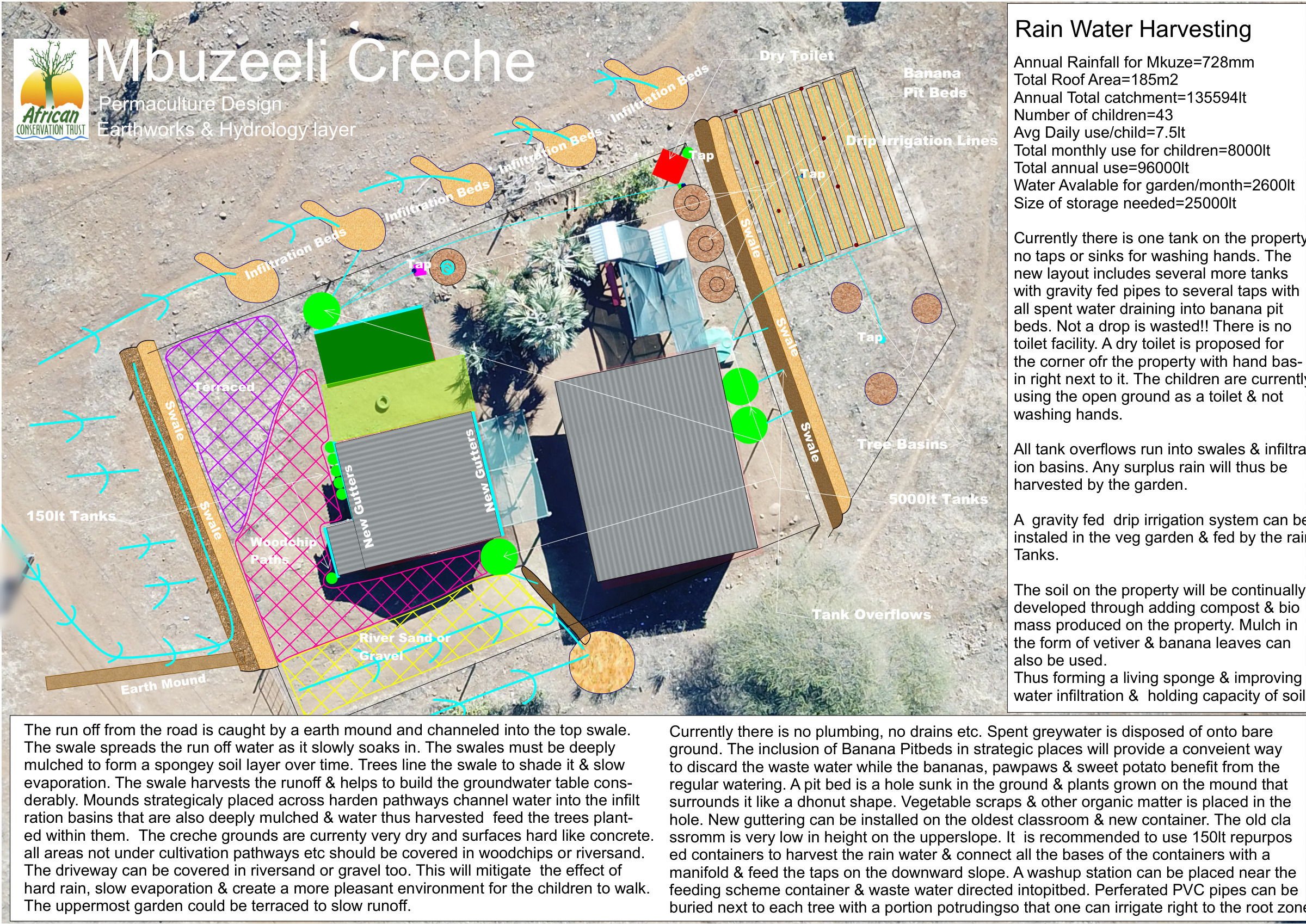
A2 earthworks and hydrology sheet for Mbuzeli Crèche: swales, infiltration beds, tanks and tree basins drawn over a drone orthophoto of the crèche, with a rain-water harvesting panel that works the roof catchment from the local rainfall figure and the number of children
Mbuzeli Crèche · Earthworks & hydrologyJuly 2019 · drone orthophoto base · A2 · the sheet spells the site Mbuzeeli
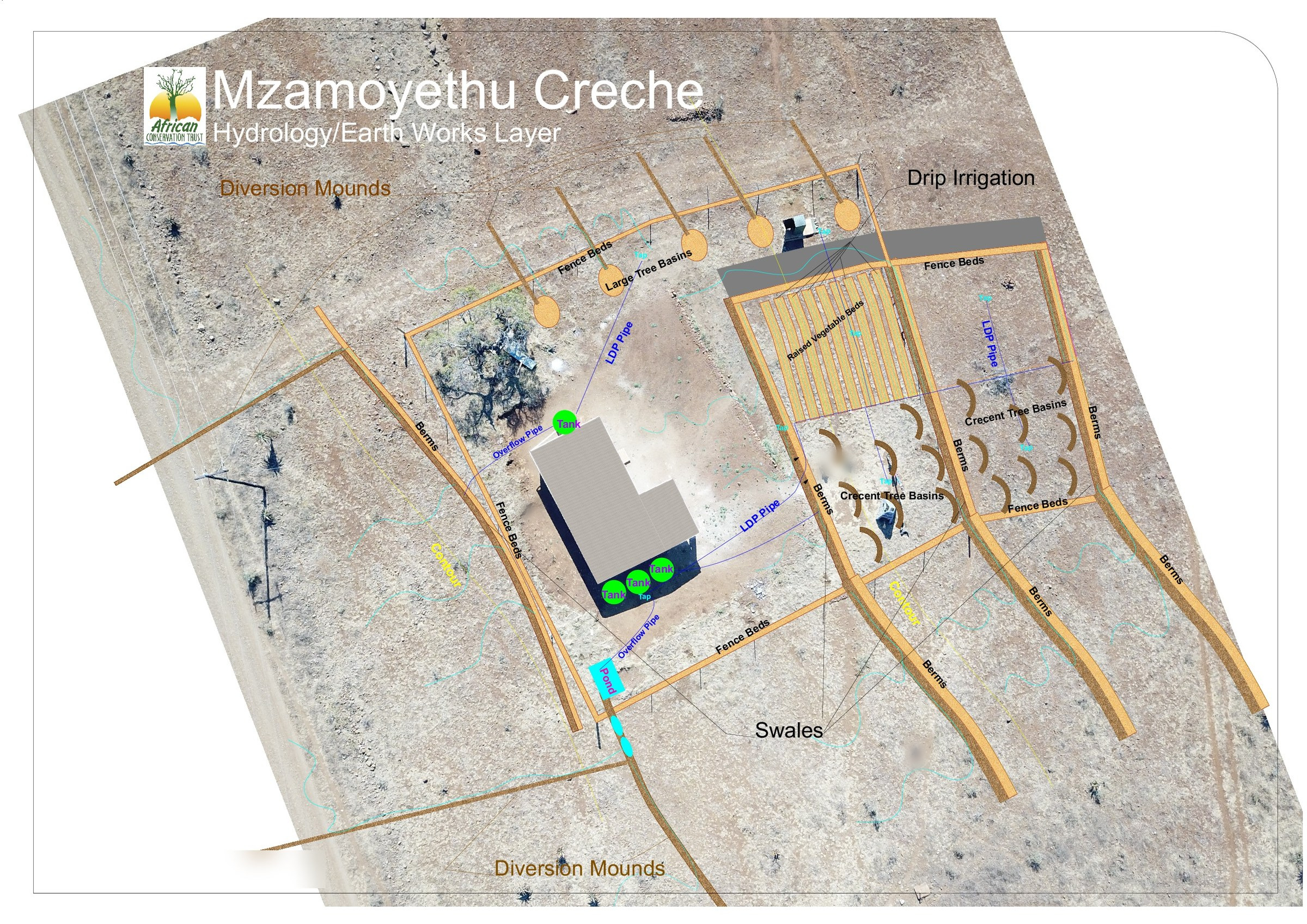
A3 earthworks and hydrology sheet for Mzamoyethu Crèche: diversion mounds, swales, drip irrigation lines and a tank drawn over a drone orthophoto of the crèche
Mzamoyethu Crèche · Earthworks & hydrologyOctober 2019 · drone orthophoto base
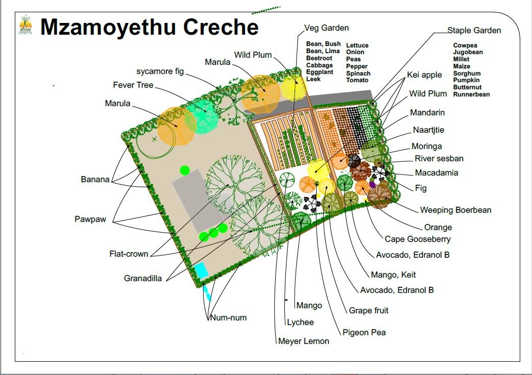
Mzamoyethu Crèche plant layer on a white ground: a vegetable garden and a staple garden as hatched blocks, fruit and shade trees as circles, every species named
Mzamoyethu Crèche · Plant layerc. 2019 · Mandlakazi crèche programme
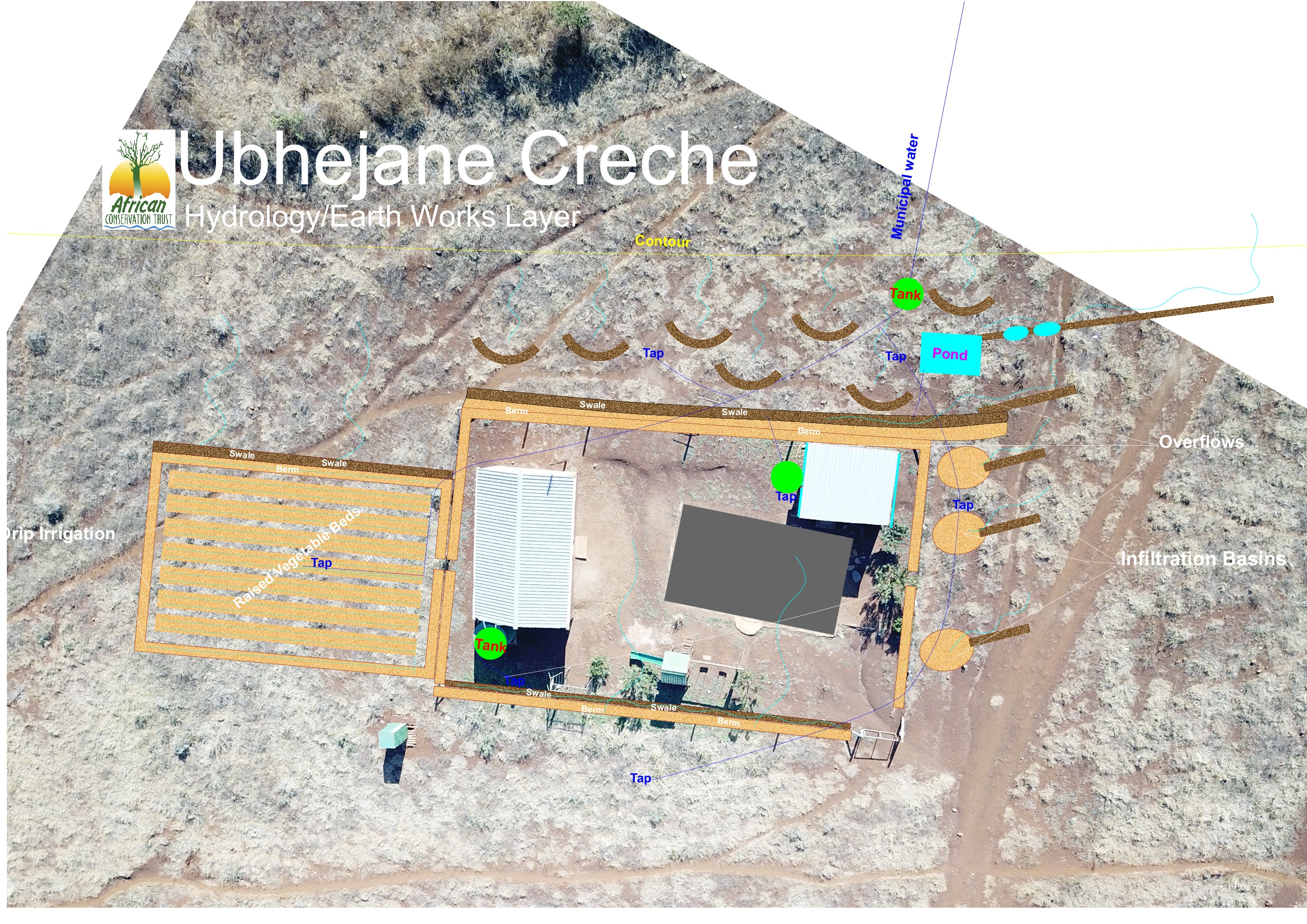
A3 hydrology and earthworks layer for Ubhejane Crèche: swales, berms, tanks, a pond, infiltration basins and raised vegetable beds drawn over a drone orthophoto of the crèche
Ubhejane Crèche · Hydrology & earthworksOctober 2019 · drone orthophoto base
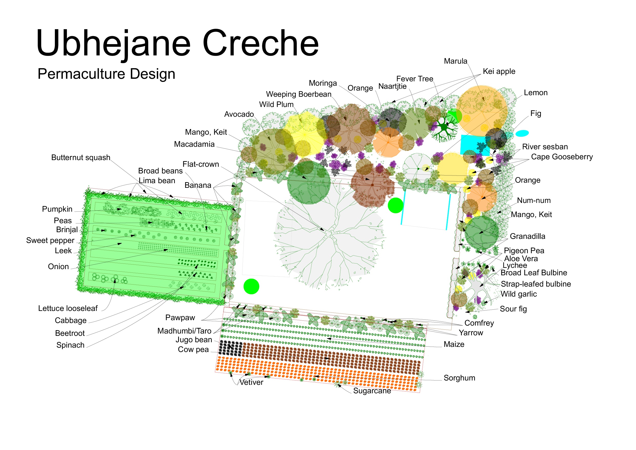
Ubhejane Crèche permaculture design on a white ground: a vegetable garden of named beds, a staple-crop block and fruit, nut and indigenous trees drawn as circles, every species labelled
Ubhejane Crèche · Permaculture designOctober 2019
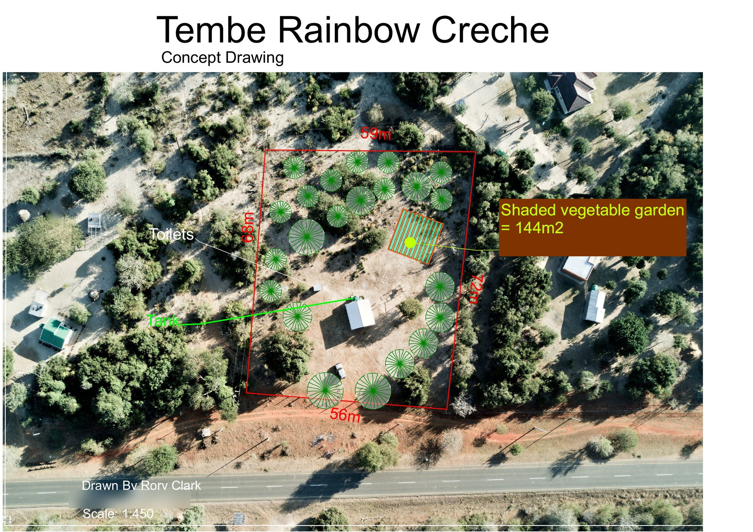
A3 concept sheet for the Tembe Rainbow Crèche garden in the Jozini area: beds, tree circles, a tank and fencing drawn over satellite imagery
Tembe Rainbow Crèche · ConceptSeptember 2021 · base imagery: Google Earth
The Ubhejane Crèche record

RVCC demonstration gardens · Lesotho

Khoelenya and Lithipeng demonstration gardens.

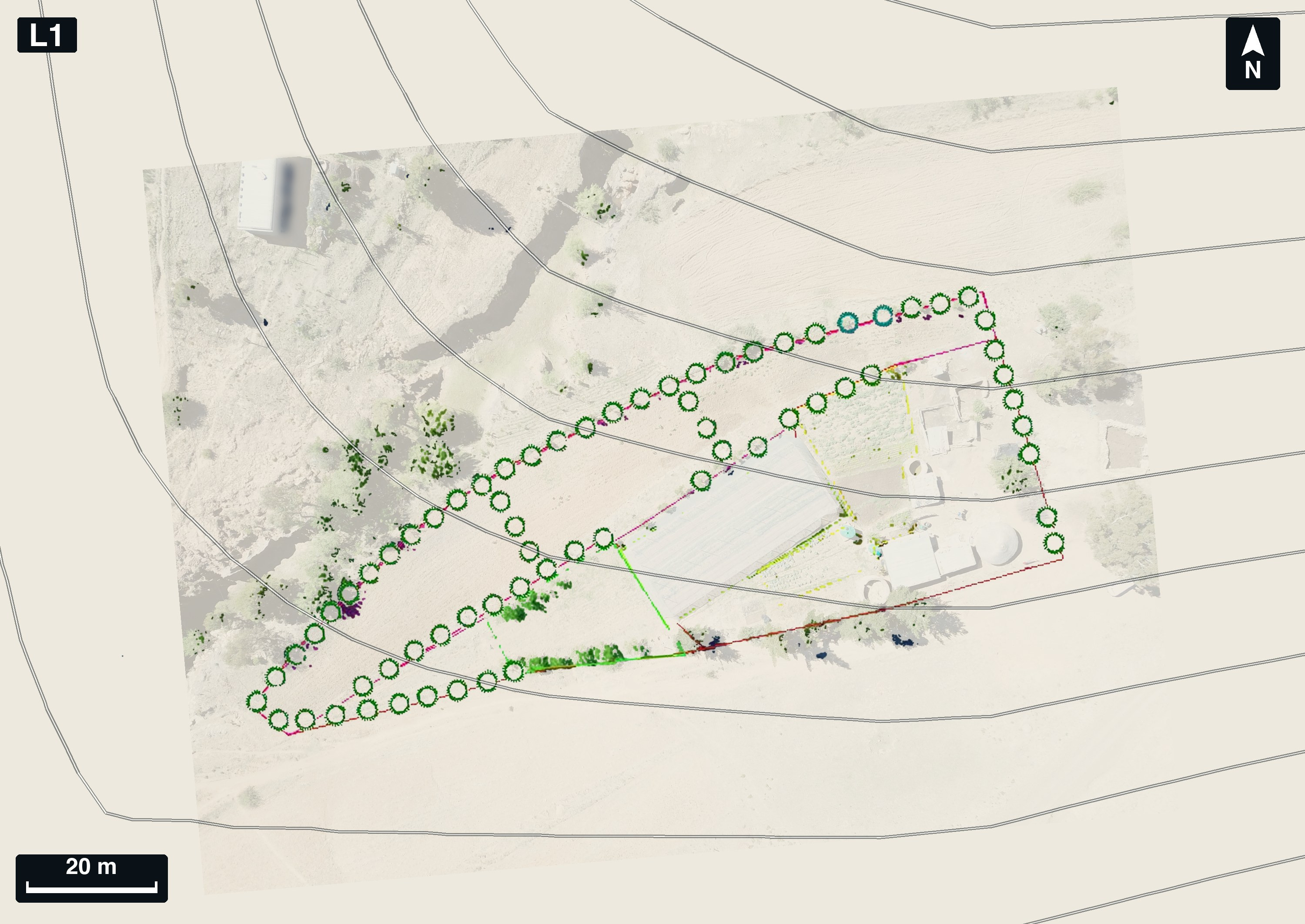
Plans for two RVCC demonstration gardens in Lesotho, showing tree basins, growing beds, tanks and water supply. The 2021 drawings use drone surveys of each site; the Lesotho project page includes the wider garden network.
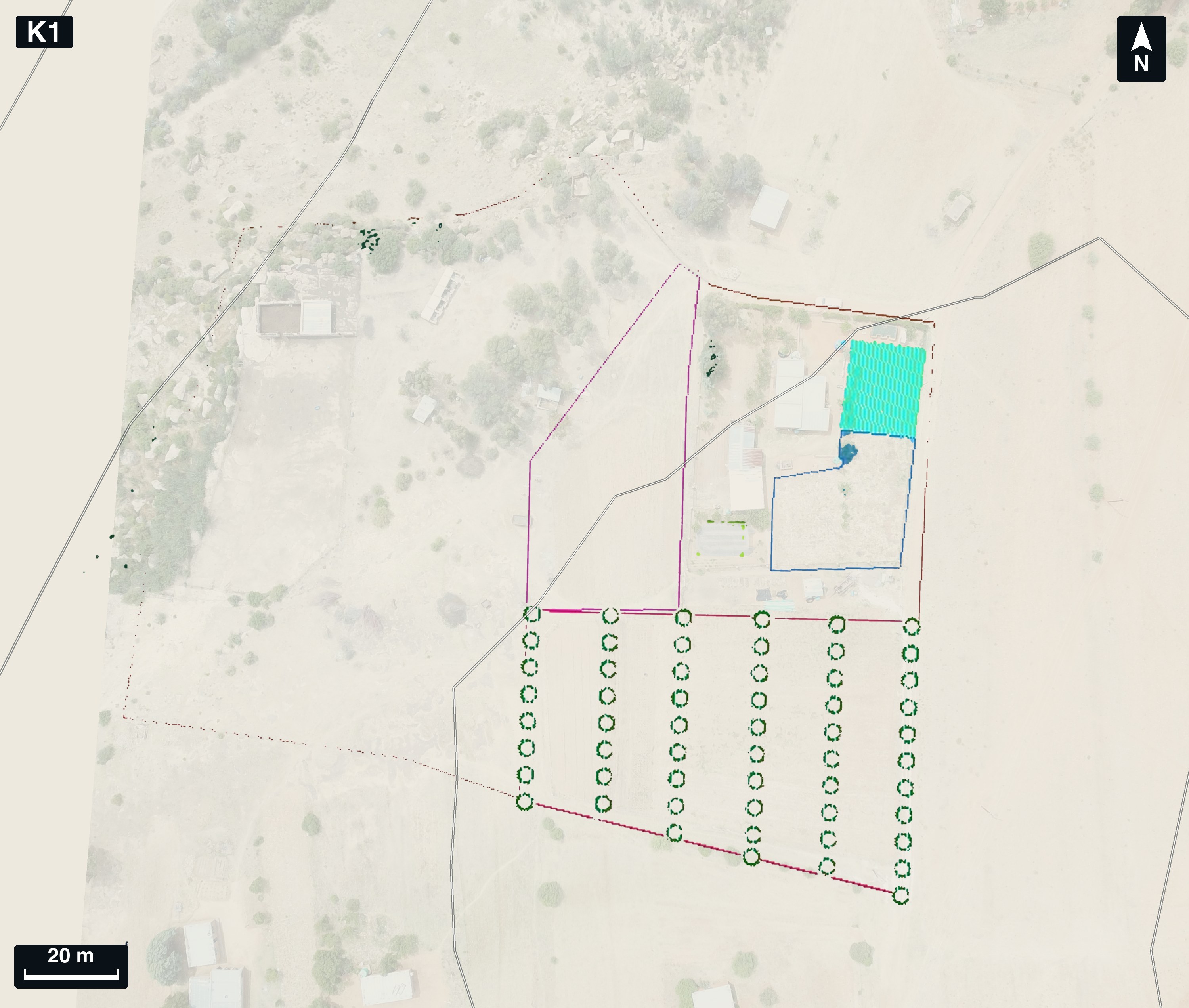
Line-work plan of demonstration garden K1 in Lesotho on a plain ground with a faint drone footprint: six rows of tree basins drawn as circles, a hatched tank, house outlines, a pipe run and the boundary, with a scale bar and north arrow
K1 · Khoelenya demonstration garden2021 · RVCC site plan
Line-work plan of demonstration garden L1 in Lesotho on a plain ground with a faint drone footprint: a ring of tree basins around the boundary, inner tree rows, bed blocks and a tank, with a scale bar and north arrow
L1 · Lithipeng demonstration garden2021 · RVCC site plan
Lesotho project and garden network

Earlier and other drawings · 2016 — 2024

School gardens, farms, nurseries and water systems.

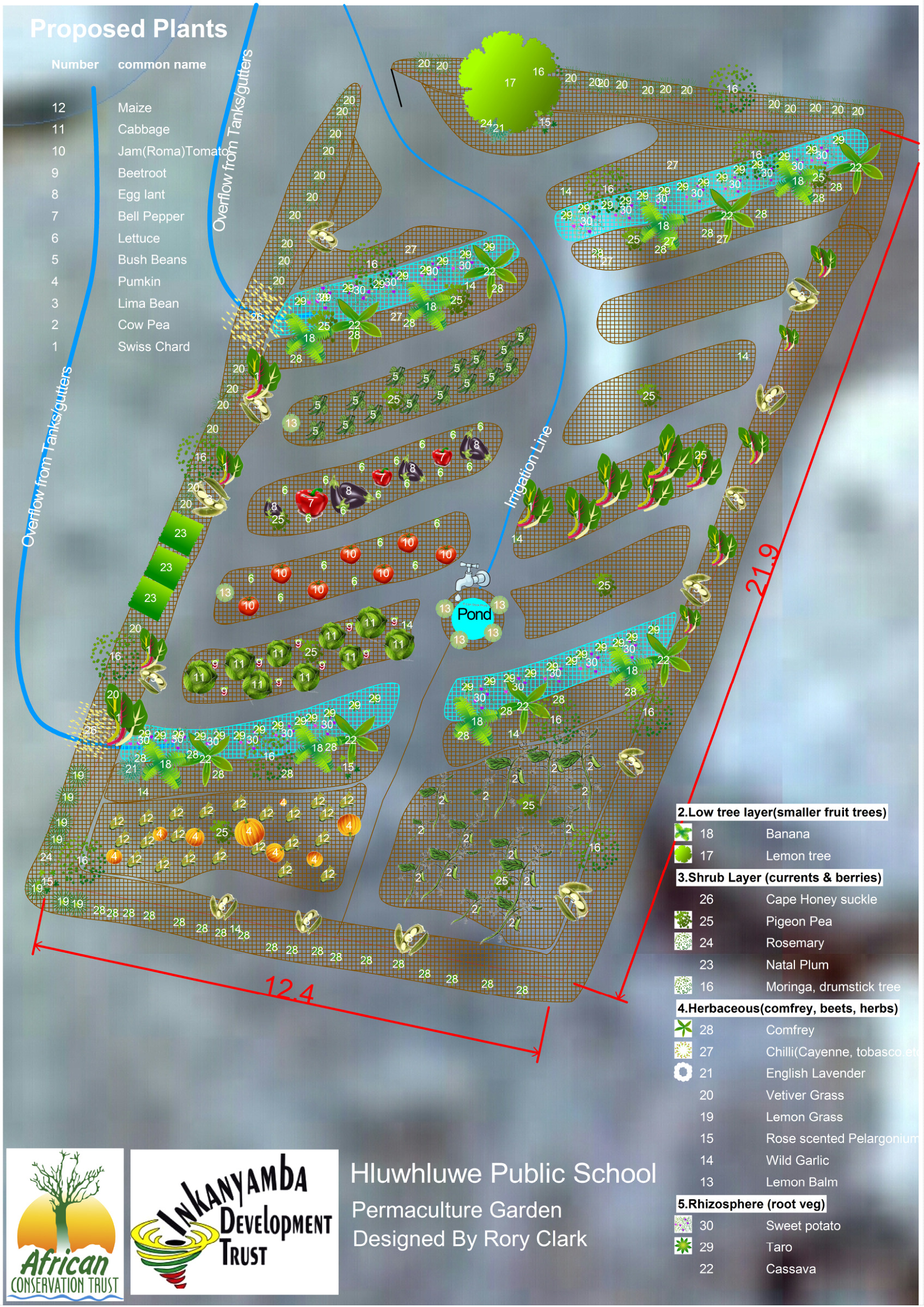
Drawings from 2016–2024 include school gardens, KwaDabeka allotments, farm irrigation, nursery tunnels, roof-water harvesting and market-garden crop plans.
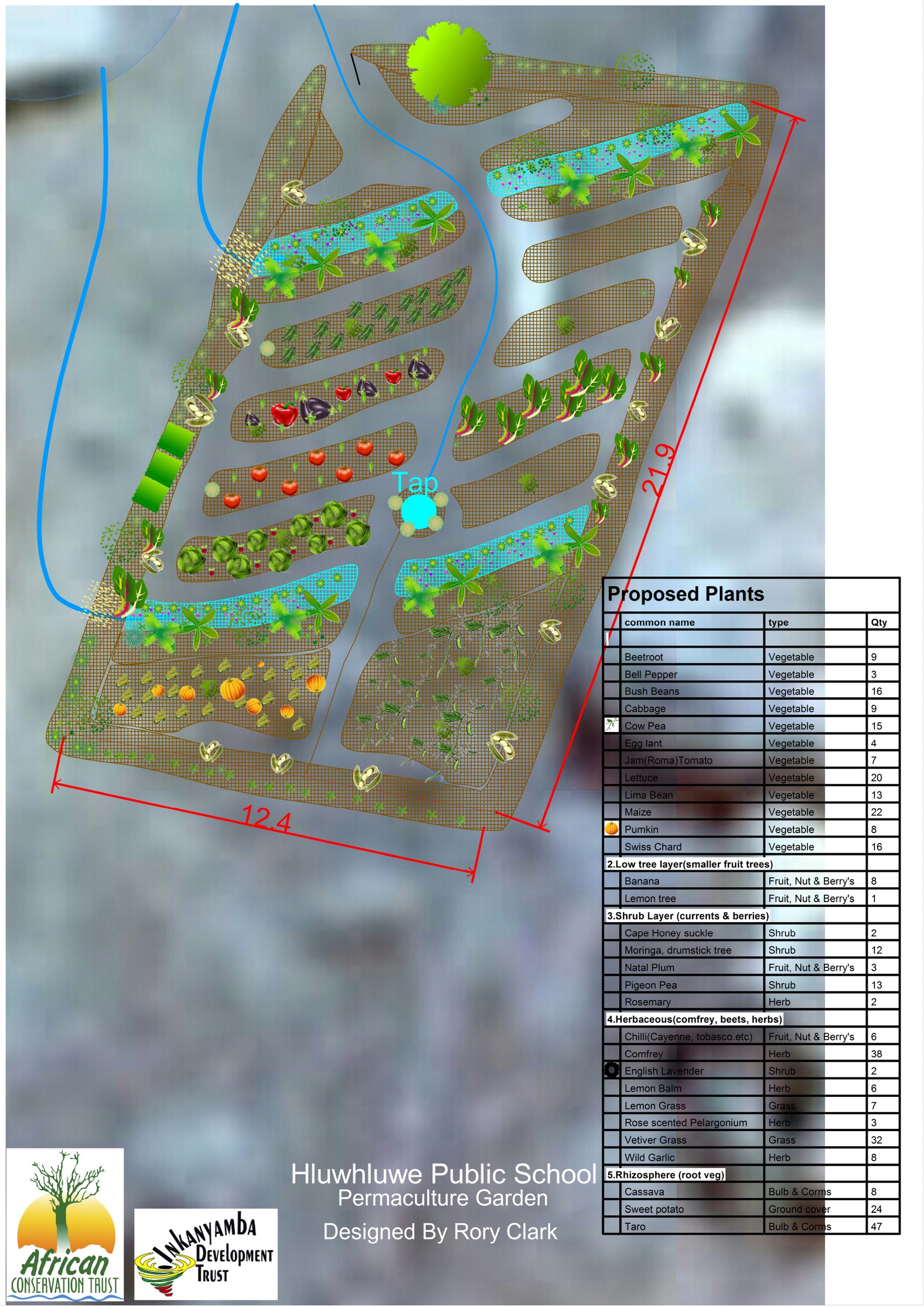
Portrait design sheet for a permaculture garden at Hluhluwe Public School: wave-shaped bed rows and paths drawn over satellite imagery of the school grounds
Hluhluwe Public School · Permaculture designMay 2016 · base imagery: Google Earth
Portrait plant layer for the Hluhluwe Public School permaculture garden: numbered trees, shrubs and vegetables keyed to a proposed-plants list, wave-shaped beds, a pond and overflow lines, with the garden dimensions marked
Hluhluwe Public School · Plant layerMay 2016 · numbered plant list · the sheet spells the school Hluwhluwe
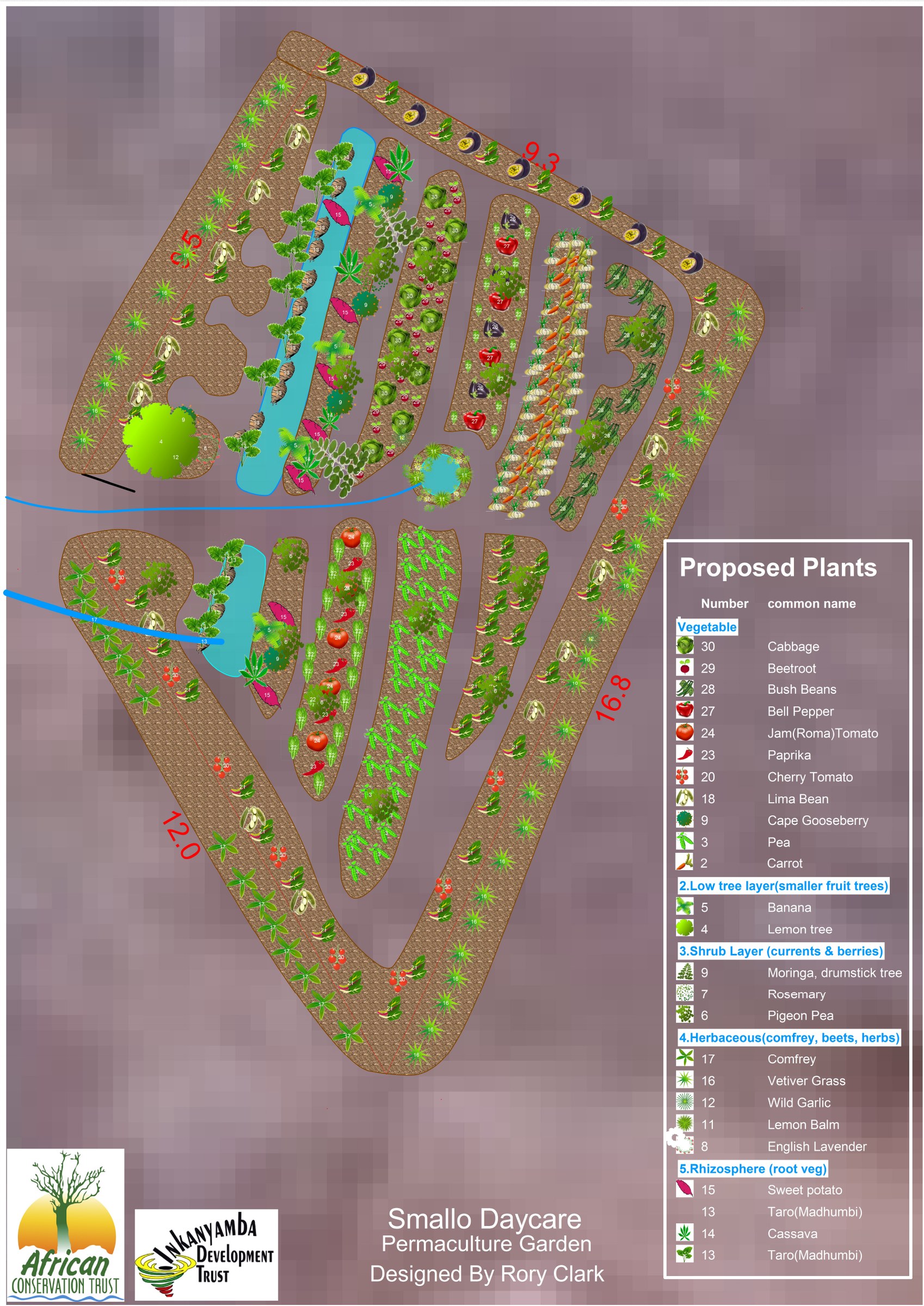
Portrait design sheet for a permaculture garden at Smallo Daycare: beds, tree circles and paths drawn over satellite imagery
Smallo Daycare · Permaculture designJuly 2016 · base imagery: Google Earth
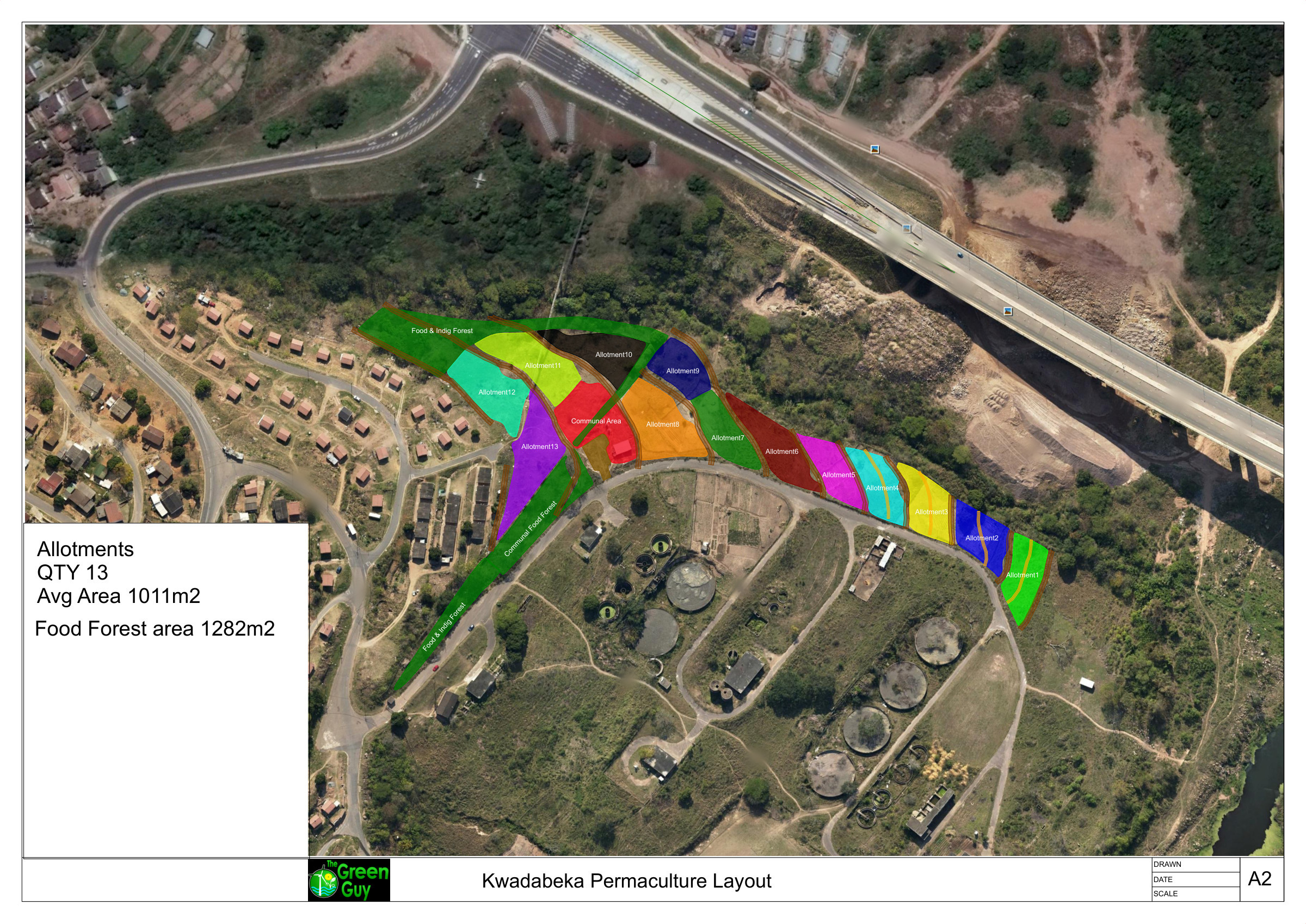
A2 layout sheet for KwaDabeka: thirteen colour-coded allotments and a food-forest strip drawn over satellite imagery of the site between the houses and the highway, with a panel giving the allotment count, average area and food-forest area
KwaDabeka · Permaculture layoutNovember 2017 · base imagery: Google Earth · A2
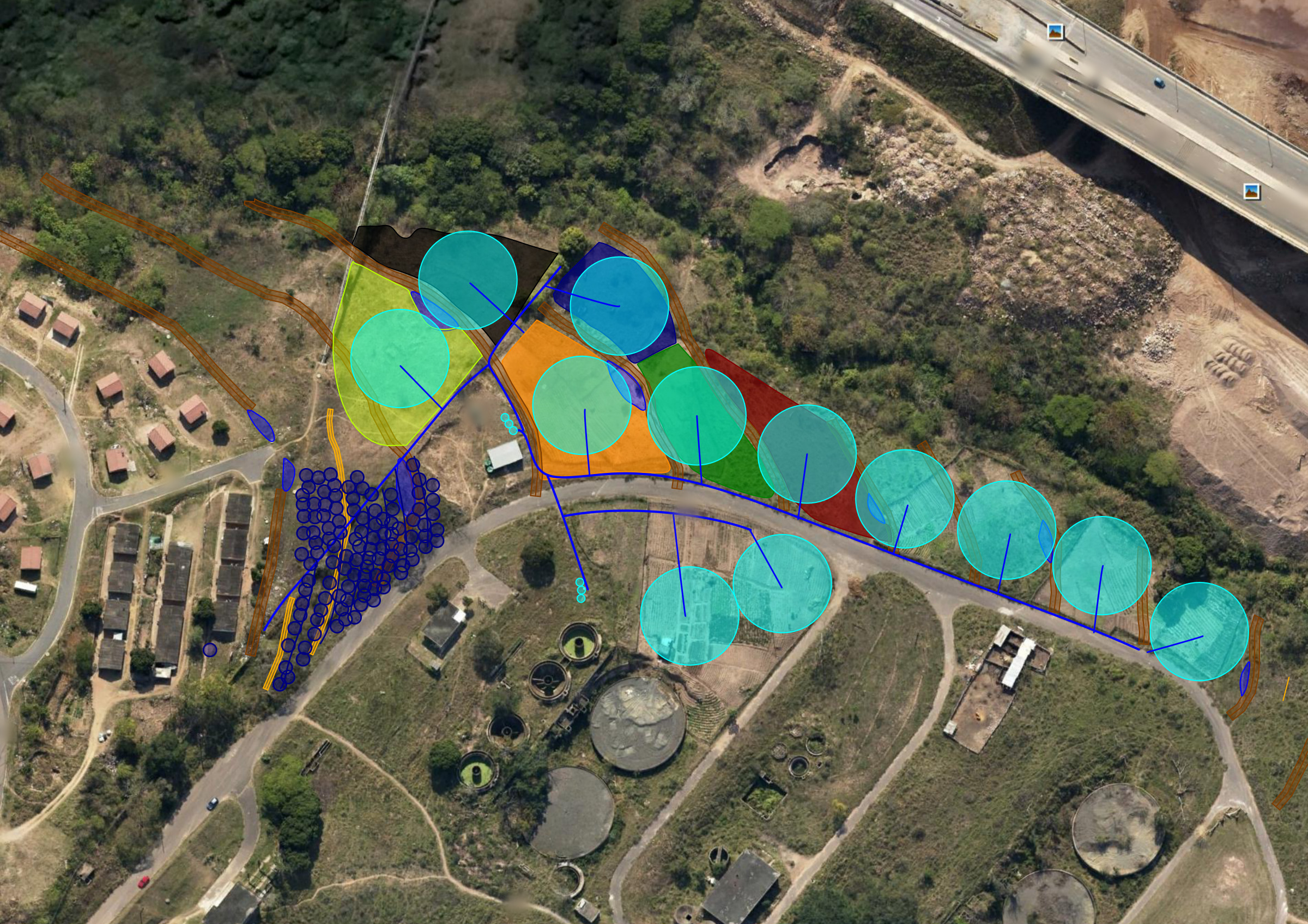
Revised KwaDabeka layout: colour-filled allotments, a row of tree circles, a cluster of micro-sprayer circles, swales and pipe lines drawn over satellite imagery of the site
KwaDabeka · Revised layoutFebruary 2018 · base imagery: Google Earth
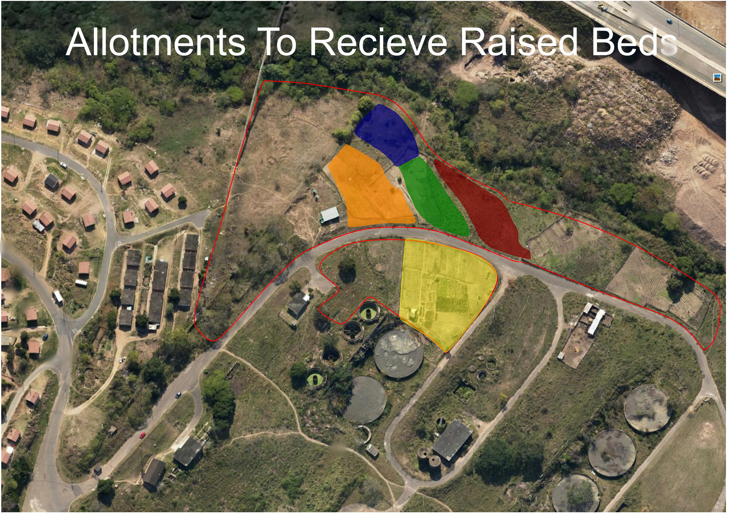
KwaDabeka sheet marking the allotments to receive raised beds: five colour-filled allotments inside the red site outline, drawn over satellite imagery
KwaDabeka · Allotments to receive raised bedsFebruary 2018 · base imagery: Google Earth · title as drawn on the sheet
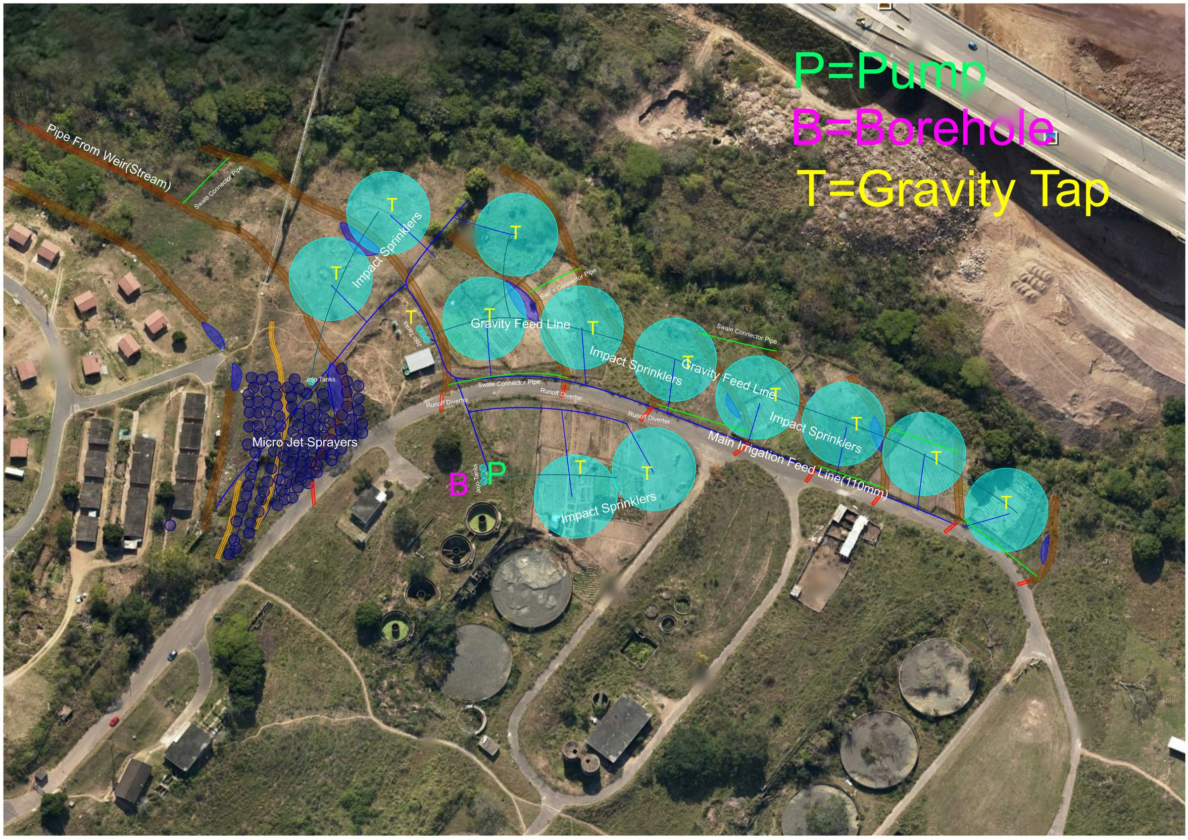
Irrigation plan for a container garden at KwaDabeka: pipe runs, taps and bed blocks drawn over satellite imagery
KwaDabeka container garden · Irrigation planFebruary 2018 · base imagery: Google Earth
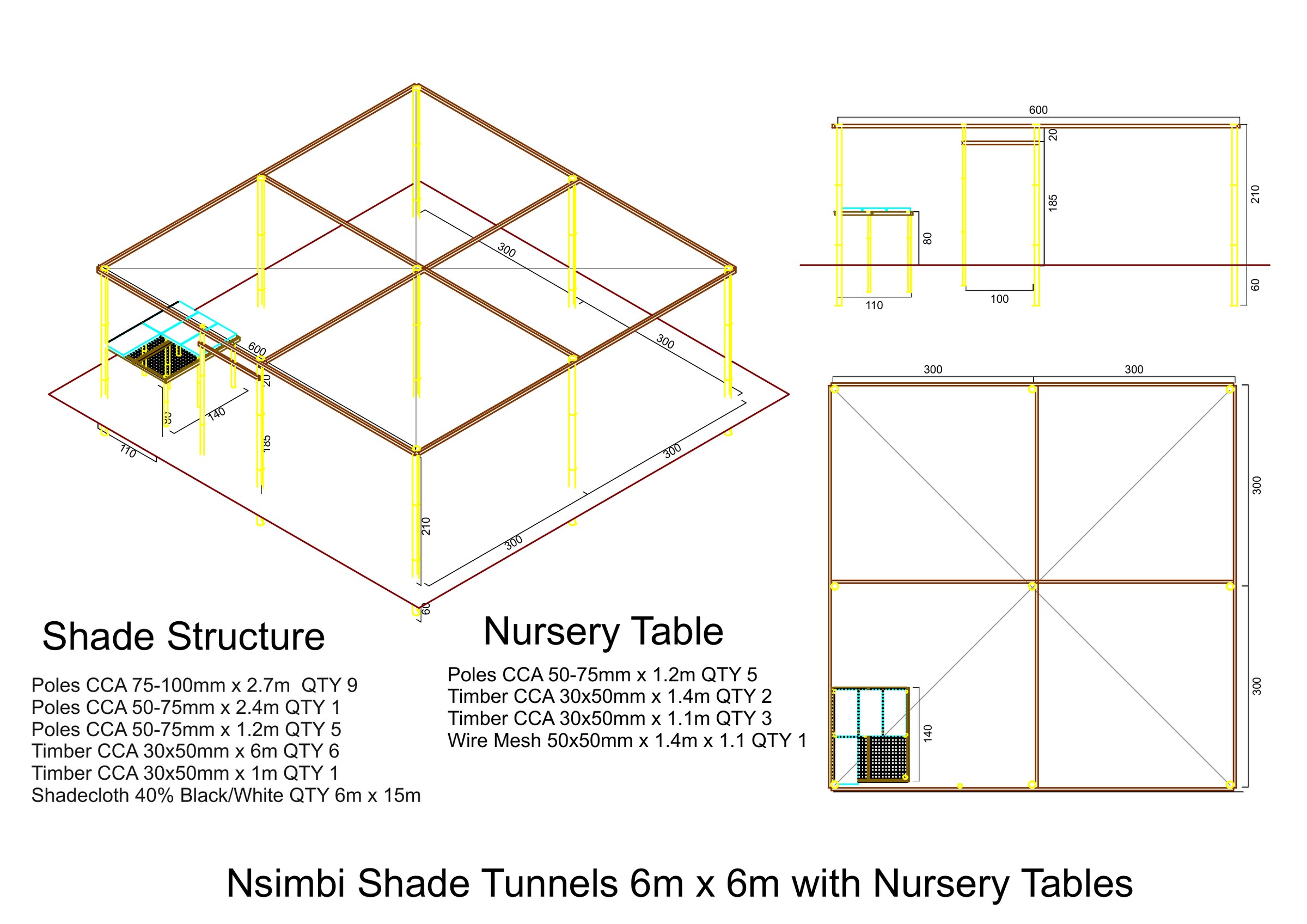
Construction drawing for shade-tunnel nurseries at Nsimbi: plan, elevation and section of the tunnels with dimensions
Nsimbi · Shade-tunnel nurseriesNovember 2018 · construction drawing
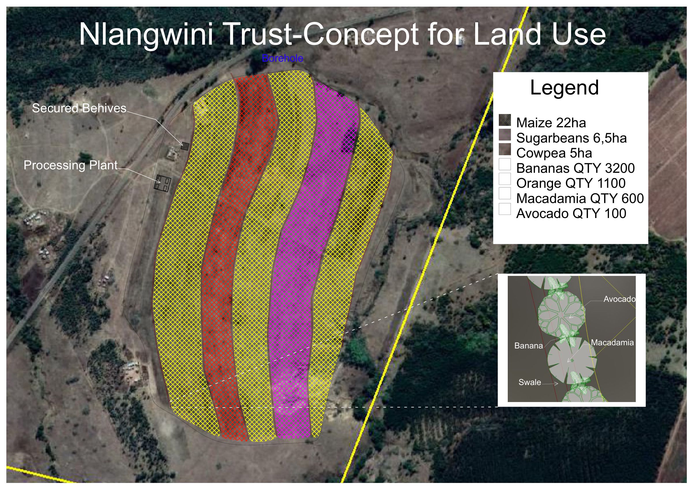
Land-use concept for the Hlengweni Trust farm: hatched blocks for maize, sugar beans and cowpea with a legend of areas and tree counts for bananas, orange, macadamia and avocado, secured beehives, a processing plant and a borehole marked over satellite imagery, with a detail of the orchard rows along a swale
Hlengweni Trust · Land-use conceptMarch 2019 · base imagery: Google Earth · titled Nlangwini Trust on the sheet
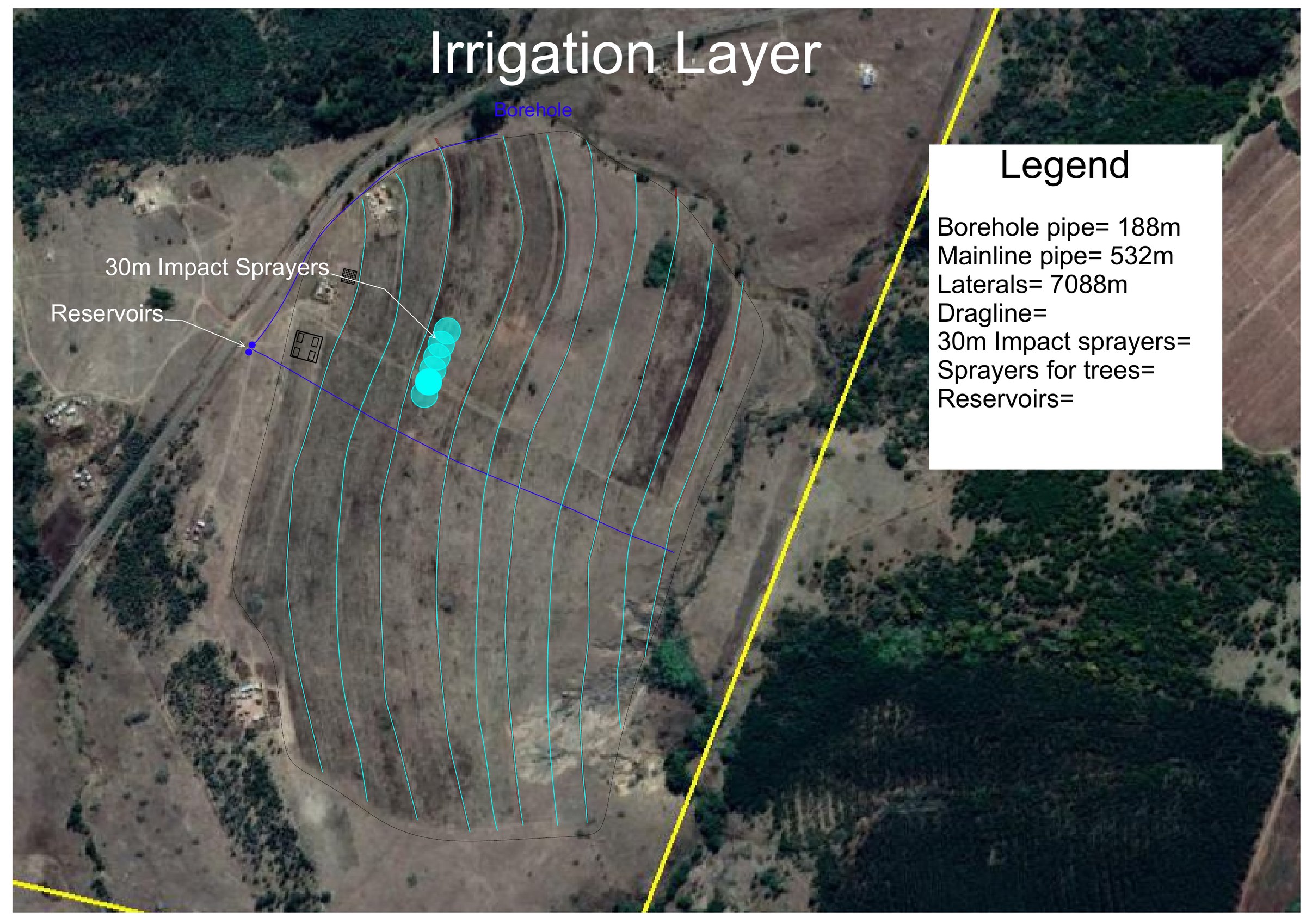
Irrigation layer for the Hlengweni Trust farm: mainline and laterals drawn over satellite imagery
Hlengweni Trust · Irrigation layerMarch 2019 · base imagery: Google Earth
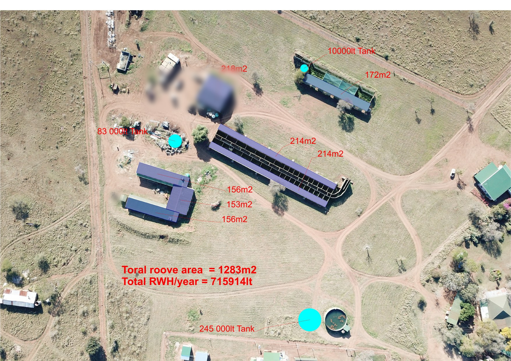
Rainwater harvesting drawing for the Manyoni Game Reserve office: roof catchment areas with their sizes and the tanks they feed, drawn over a drone orthophoto
Manyoni Game Reserve office · Rainwater harvestingJanuary 2022
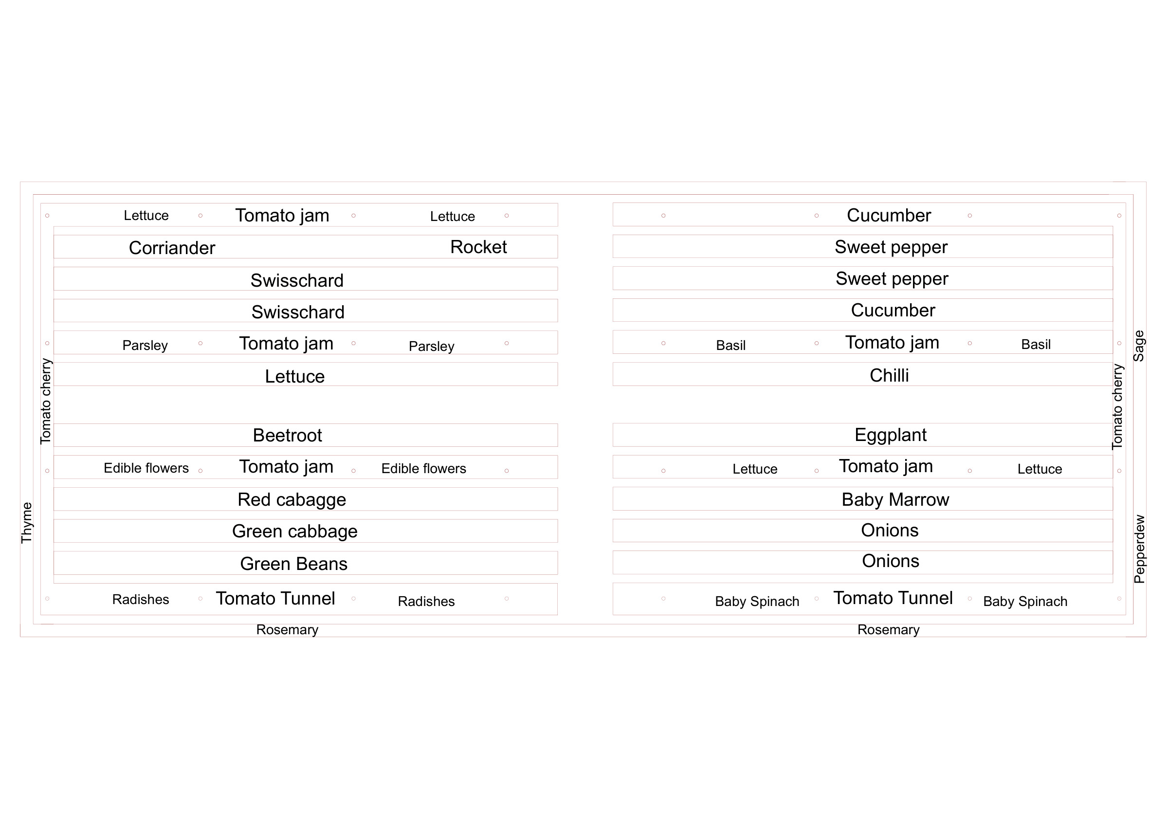
Rory Clark’s crop and bed layout for the Manyoni organic market garden
Manyoni organic market garden · LayoutAugust 2022 · a year after the August 2021 proposal
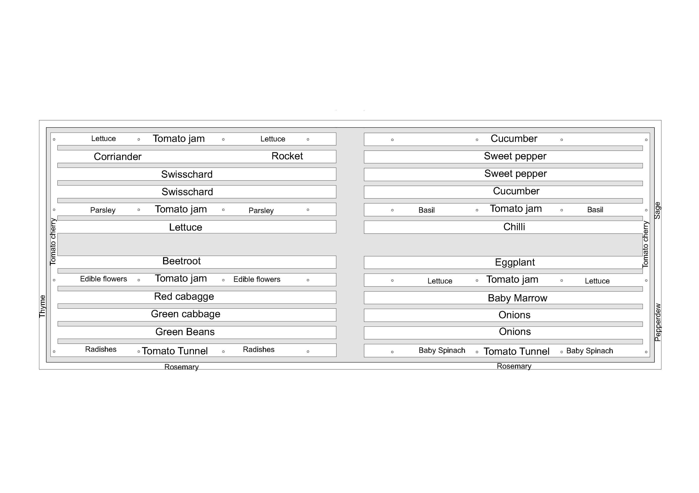
Crop plan for the Manyoni organic market garden on a white ground: two blocks of beds with a crop written on each, tomato tunnels at the foot of each block and herbs along the edges
Manyoni organic market garden · Crop planAugust 2022 · crop assignment per bed
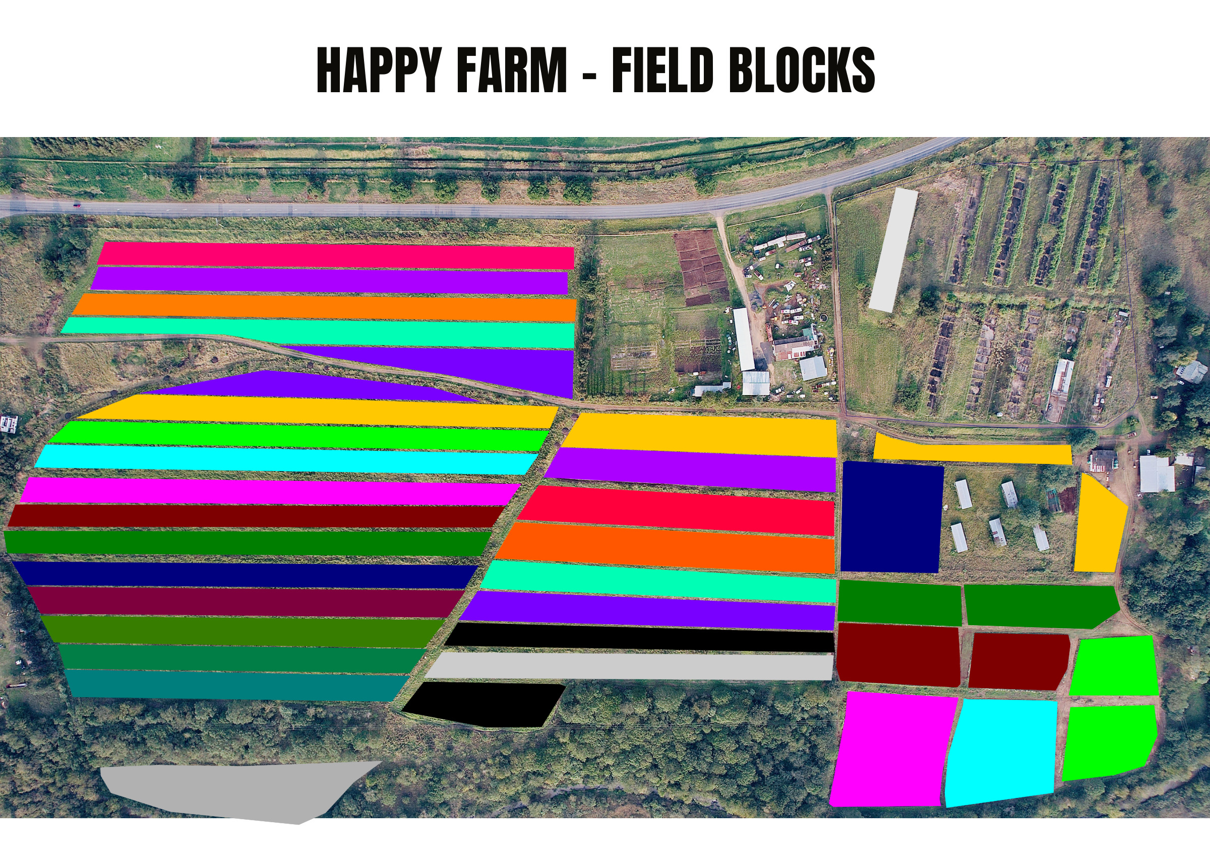
Field-block layout for Happy Farm: colour-coded blocks drawn over an aerial photograph of the farm, its road and the neighbouring plots
Happy Farm · Field blocksJune 2024 · aerial photograph base

About the sheets

Sources and publication notes.

Read the field evidence

Dates & base maps

Dates come from the drawing files. Base maps use drone orthophotos, Google Earth imagery or a combination of both, as identified on each sheet.

Privacy on the sheets

Phone numbers have been removed and people in aerial images blurred. Base maps showing mainly people have been omitted.

The supporting record

The Ubhejane Crèche and Lesotho project pages include the reports accompanying their designs.